You are here: Home > Network List > IU - Global Seismograph Network (GSN - IRIS/USGS) Stations List
> Station GNI Garni, Armenia > Earthquake Result Viewer
GNI Garni, Armenia - Earthquake Result Viewer

| Earthquake location: |
Azores Islands, Portugal |
| Earthquake latitude/longitude: |
38.3/-26.7 |
| Earthquake time(UTC): |
1997/06/27 (178) 04:39:52 GMT |
| Earthquake Depth: |
10 km |
| Earthquake Magnitude: |
5.6 MB, 5.4 MS, 5.9 UNKNOWN, 5.9 MW |
| Earthquake Catalog/Contributor: |
WHDF/NEIC |
|
| Network: |
IU Global Seismograph Network (GSN - IRIS/USGS) |
| Station: |
GNI Garni, Armenia |
| Lat/Lon: |
40.15 N/44.74 E |
| Elevation: |
1609 m |
|
| Distance: |
53.9 deg |
| Az: |
64.008 deg |
| Baz: |
292.748 deg |
| Ray Param: |
0.06576734 |
| Estimated Moho Depth: |
37.0 km |
| Estimated Crust Vp/Vs: |
1.98 |
| Assumed Crust Vp: |
6.291 km/s |
| Estimated Crust Vs: |
3.185 km/s |
| Estimated Crust Poisson's Ratio: |
0.33 |
|
| Radial Match: |
84.14762 % |
| Radial Bump: |
400 |
| Transverse Match: |
84.287735 % |
| Transverse Bump: |
400 |
| SOD ConfigId: |
4480 |
| Insert Time: |
2010-03-03 13:47:06.086 +0000 |
| GWidth: |
2.5 |
| Max Bumps: |
400 |
| Tol: |
0.001 |
|
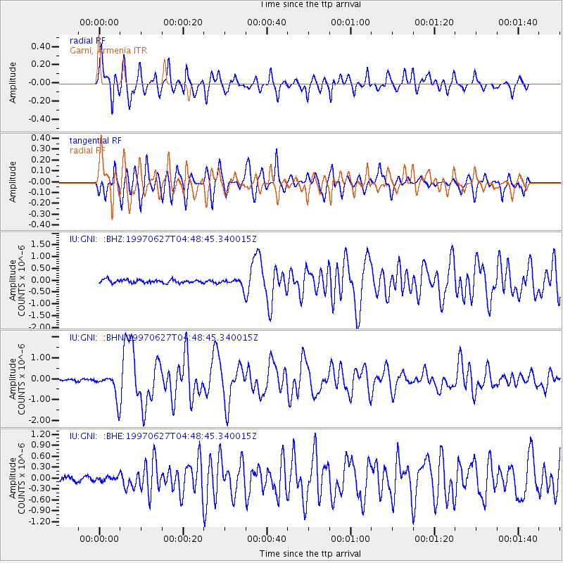
Signal To Noise
| Channel | StoN | STA | LTA |
| IU:GNI: :BHN:19970627T04:48:45.340015Z | 9.2908535 | 6.356232E-7 | 6.841386E-8 |
| IU:GNI: :BHE:19970627T04:48:45.340015Z | 0.94901997 | 6.380343E-8 | 6.7230864E-8 |
| IU:GNI: :BHZ:19970627T04:48:45.340015Z | 2.8246841 | 1.9181802E-7 | 6.790777E-8 |
| Arrivals |
| Ps | 6.0 SECOND |
| PpPs | 17 SECOND |
| PsPs/PpSs | 23 SECOND |


