You are here: Home > Network List > IU - Global Seismograph Network (GSN - IRIS/USGS) Stations List
> Station GNI Garni, Armenia > Earthquake Result Viewer
GNI Garni, Armenia - Earthquake Result Viewer
| Earthquake location: |
Kuril Islands |
| Earthquake latitude/longitude: |
46.5/153.4 |
| Earthquake time(UTC): |
2006/09/28 (271) 01:36:48 GMT |
| Earthquake Depth: |
11 km |
| Earthquake Magnitude: |
5.8 MB, 5.5 MS, 5.9 MW, 5.9 MW |
| Earthquake Catalog/Contributor: |
WHDF/NEIC |
|
| Network: |
IU Global Seismograph Network (GSN - IRIS/USGS) |
| Station: |
GNI Garni, Armenia |
| Lat/Lon: |
40.15 N/44.74 E |
| Elevation: |
1609 m |
|
| Distance: |
72.8 deg |
| Az: |
310.518 deg |
| Baz: |
43.281 deg |
| Ray Param: |
0.053389404 |
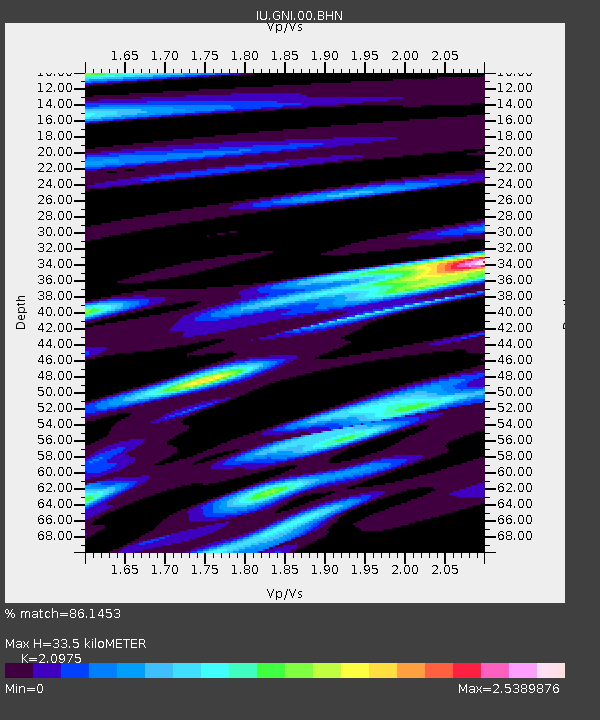
| Estimated Moho Depth: |
33.5 km |
| Estimated Crust Vp/Vs: |
2.10 |
| Assumed Crust Vp: |
6.291 km/s |
| Estimated Crust Vs: |
2.999 km/s |
| Estimated Crust Poisson's Ratio: |
0.35 |
|
| Radial Match: |
86.1453 % |
| Radial Bump: |
400 |
| Transverse Match: |
85.46043 % |
| Transverse Bump: |
400 |
| SOD ConfigId: |
2564 |
| Insert Time: |
2010-03-03 13:47:11.912 +0000 |
| GWidth: |
2.5 |
| Max Bumps: |
400 |
| Tol: |
0.001 |
|
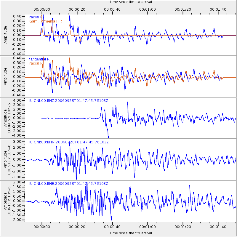
Signal To Noise
| Channel | StoN | STA | LTA |
| IU:GNI:00:BHN:20060928T01:47:45.76103Z | 4.0443134 | 2.8426257E-7 | 7.028697E-8 |
| IU:GNI:00:BHE:20060928T01:47:45.76103Z | 3.1495588 | 1.6432541E-7 | 5.217411E-8 |
| IU:GNI:00:BHZ:20060928T01:47:45.76103Z | 12.888051 | 7.9260883E-7 | 6.149951E-8 |
| Arrivals |
| Ps | 6.0 SECOND |
| PpPs | 16 SECOND |
| PsPs/PpSs | 22 SECOND |


