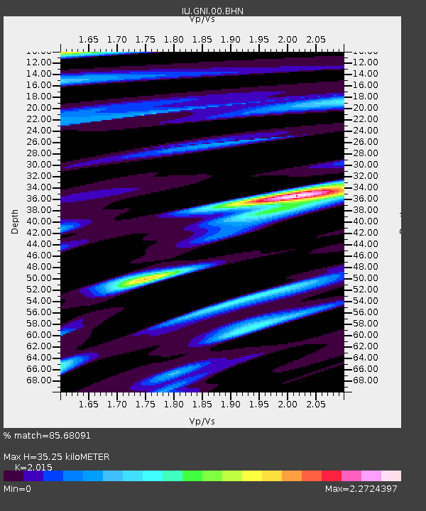
GNI Garni, Armenia - Earthquake Result Viewer
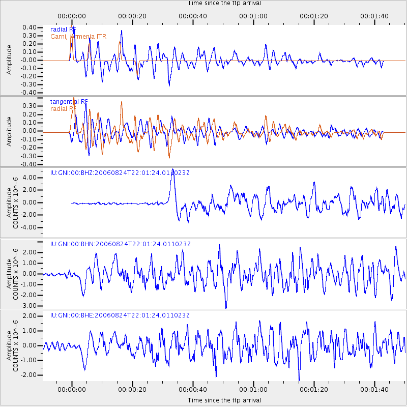
Earthquake location: Near East Coast Of Kamchatka
Earthquake latitude/longitude: 51.1/157.5
Earthquake time(UTC): 2006/08/24 (236) 21:50:36 GMT
Earthquake Depth: 43 km
Earthquake Magnitude: 5.9 MB, 6.2 MS, 6.5 MW, 6.5 MW
Earthquake Catalog/Contributor: WHDF/NEIC
Network: IU Global Seismograph Network (GSN - IRIS/USGS)
Station: GNI Garni, Armenia
Lat/Lon: 40.15 N/44.74 E
Elevation: 1609 m
Distance: 71.8 deg
Az: 311.942 deg
Baz: 37.678 deg
Ray Param: 0.05399048
Estimated Moho Depth: 35.25 km
Estimated Crust Vp/Vs: 2.02
Assumed Crust Vp: 6.291 km/s
Estimated Crust Vs: 3.122 km/s
Estimated Crust Poisson's Ratio: 0.34
Radial Match: 85.68091 %
Radial Bump: 400
Transverse Match: 84.95133 %
Transverse Bump: 400
SOD ConfigId: 2564
Insert Time: 2010-03-03 13:47:16.226 +0000
GWidth: 2.5
Max Bumps: 400
Tol: 0.001

Signal To Noise

ChannelStoNSTALTA
IU:GNI:00:BHN:20060824T22:01:24.011023Z11.3846388.404593E-77.382398E-8
IU:GNI:00:BHE:20060824T22:01:24.011023Z5.7287466.586687E-71.1497607E-7
IU:GNI:00:BHZ:20060824T22:01:24.011023Z31.6927032.4052351E-67.5892395E-8
Arrivals
Ps5.9 SECOND
PpPs16 SECOND
PsPs/PpSs22 SECOND