You are here: Home > Network List > US - United States National Seismic Network Stations List
> Station MNTX Cornudas Mountains, Texas, USA > Earthquake Result Viewer
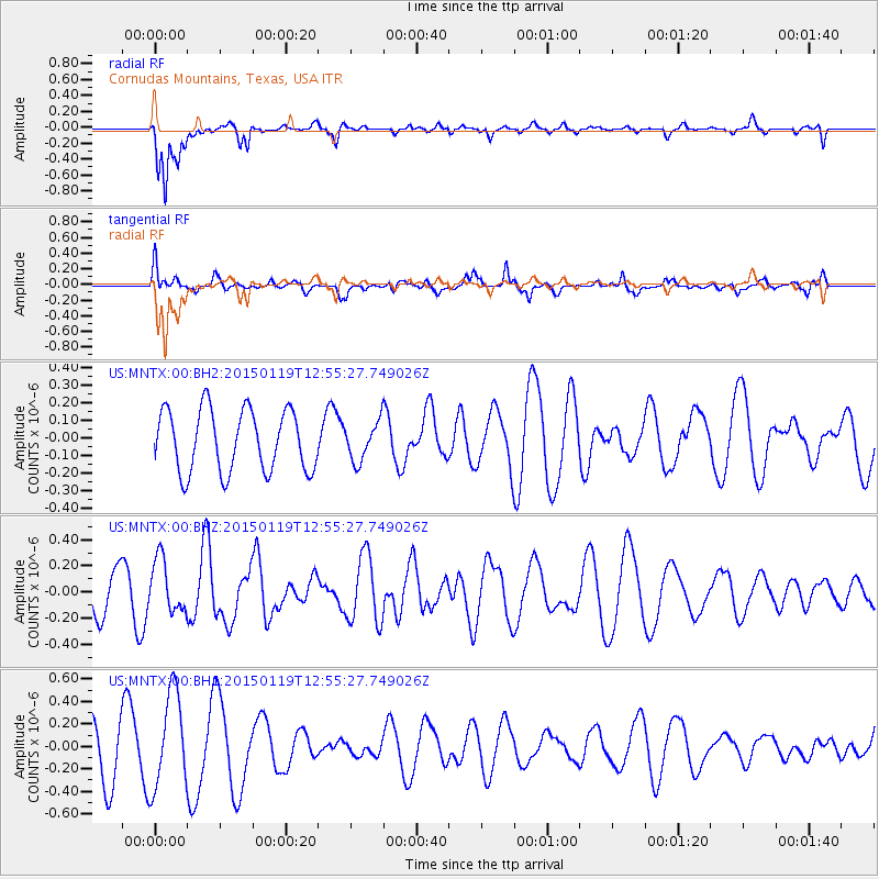
MNTX Cornudas Mountains, Texas, USA - Earthquake Result Viewer
*The percent match for this event was below the threshold and hence no stack was calculated.
| Earthquake location: |
Greenland Sea |
| Earthquake latitude/longitude: |
73.2/6.4 |
| Earthquake time(UTC): |
2015/01/19 (019) 12:45:13 GMT |
| Earthquake Depth: |
10 km |
| Earthquake Magnitude: |
5.5 MB |
| Earthquake Catalog/Contributor: |
NEIC PDE/NEIC COMCAT |
|
| Network: |
US United States National Seismic Network |
| Station: |
MNTX Cornudas Mountains, Texas, USA |
| Lat/Lon: |
31.70 N/105.38 W |
| Elevation: |
404 m |
|
| Distance: |
65.9 deg |
| Az: |
299.901 deg |
| Baz: |
17.173 deg |
| Ray Param: |
$rayparam |
*The percent match for this event was below the threshold and hence was not used in the summary stack. |
|
| Radial Match: |
83.66402 % |
| Radial Bump: |
347 |
| Transverse Match: |
43.817432 % |
| Transverse Bump: |
400 |
| SOD ConfigId: |
837871 |
| Insert Time: |
2015-02-02 13:19:52.527 +0000 |
| GWidth: |
2.5 |
| Max Bumps: |
400 |
| Tol: |
0.001 |
|
Signal To Noise
| Channel | StoN | STA | LTA |
| US:MNTX:00:BHZ:20150119T12:55:27.749026Z | 1.1820698 | 2.009999E-7 | 1.7004065E-7 |
| US:MNTX:00:BH1:20150119T12:55:27.749026Z | 2.2838793 | 4.2304345E-7 | 1.8523022E-7 |
| US:MNTX:00:BH2:20150119T12:55:27.749026Z | 0.6162277 | 1.08659926E-7 | 1.763308E-7 |
| Arrivals |
| Ps | |
| PpPs | |
| PsPs/PpSs | |


