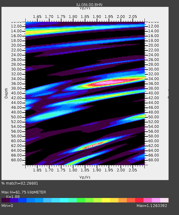
GNI Garni, Armenia - Earthquake Result Viewer
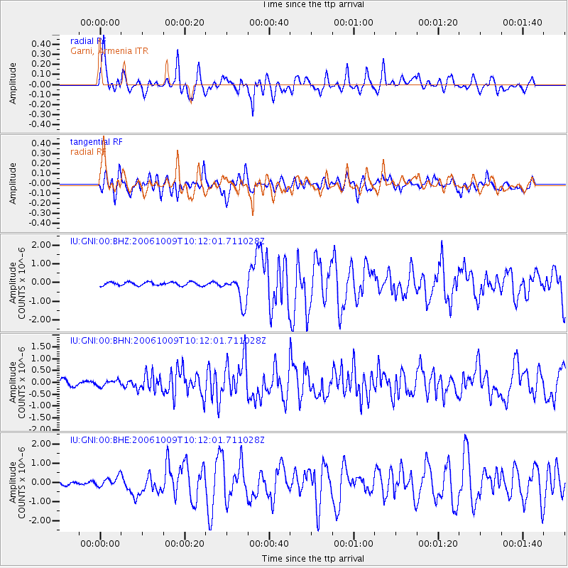
Earthquake location: Philippine Islands Region
Earthquake latitude/longitude: 20.7/120.0
Earthquake time(UTC): 2006/10/09 (282) 10:01:46 GMT
Earthquake Depth: 10 km
Earthquake Magnitude: 6.0 MB, 5.9 MS, 6.3 MW, 6.1 MW
Earthquake Catalog/Contributor: WHDF/NEIC
Network: IU Global Seismograph Network (GSN - IRIS/USGS)
Station: GNI Garni, Armenia
Lat/Lon: 40.15 N/44.74 E
Elevation: 1609 m
Distance: 65.9 deg
Az: 305.723 deg
Baz: 82.71 deg
Ray Param: 0.057940125
Estimated Moho Depth: 61.75 km
Estimated Crust Vp/Vs: 1.88
Assumed Crust Vp: 6.291 km/s
Estimated Crust Vs: 3.346 km/s
Estimated Crust Poisson's Ratio: 0.30
Radial Match: 82.26681 %
Radial Bump: 400
Transverse Match: 82.24039 %
Transverse Bump: 400
SOD ConfigId: 2665
Insert Time: 2010-03-03 13:47:48.344 +0000
GWidth: 2.5
Max Bumps: 400
Tol: 0.001

Signal To Noise

ChannelStoNSTALTA
IU:GNI:00:BHN:20061009T10:12:01.711028Z0.742107451.2287391E-71.6557428E-7
IU:GNI:00:BHE:20061009T10:12:01.711028Z2.34764842.68104E-71.142011E-7
IU:GNI:00:BHZ:20061009T10:12:01.711028Z8.1498757.633189E-79.3660205E-8
Arrivals
Ps9.0 SECOND
PpPs27 SECOND
PsPs/PpSs36 SECOND