GNI Garni, Armenia - Earthquake Result Viewer
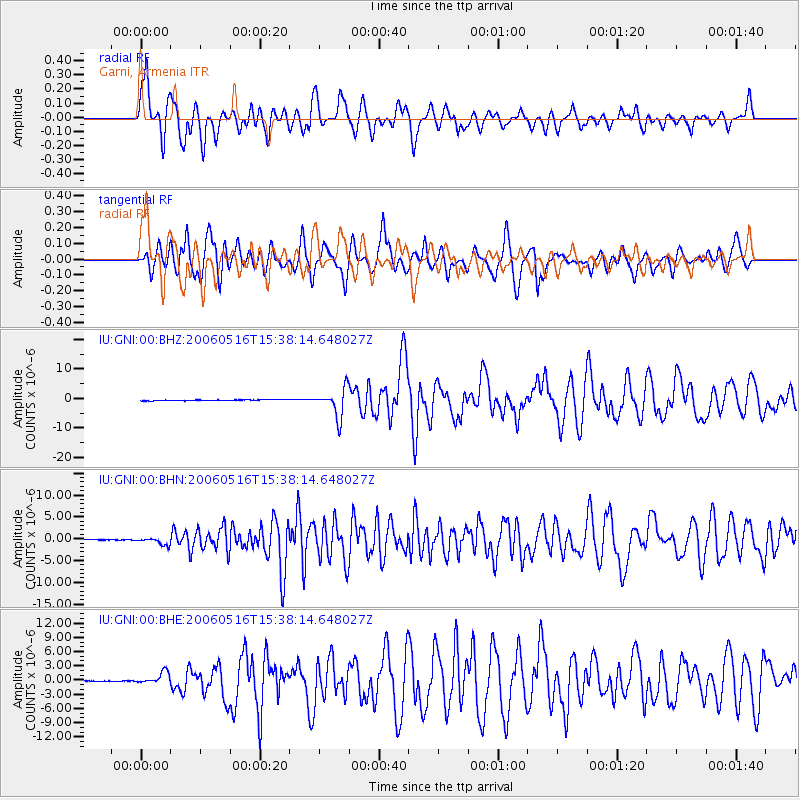
Earthquake location: Northern Sumatra, Indonesia
Earthquake latitude/longitude: 0.1/97.1
Earthquake time(UTC): 2006/05/16 (136) 15:28:25 GMT
Earthquake Depth: 12 km
Earthquake Magnitude: 6.6 MB, 6.8 MS, 6.8 MW, 6.8 MW
Earthquake Catalog/Contributor: WHDF/NEIC
Network: IU Global Seismograph Network (GSN - IRIS/USGS)
Station: GNI Garni, Armenia
Lat/Lon: 40.15 N/44.74 E
Elevation: 1609 m
Distance: 62.0 deg
Az: 316.603 deg
Baz: 116.319 deg
Ray Param: 0.06052082
Estimated Moho Depth: 69.0 km
Estimated Crust Vp/Vs: 1.82
Assumed Crust Vp: 6.291 km/s
Estimated Crust Vs: 3.466 km/s
Estimated Crust Poisson's Ratio: 0.28
Radial Match: 84.77819 %
Radial Bump: 400
Transverse Match: 77.250984 %
Transverse Bump: 400
SOD ConfigId: 2669
Insert Time: 2010-03-03 13:47:56.011 +0000
GWidth: 2.5
Max Bumps: 400
Tol: 0.001

Signal To Noise

ChannelStoNSTALTA
IU:GNI:00:BHN:20060516T15:38:14.648027Z7.51592547.74184E-71.0300581E-7
IU:GNI:00:BHE:20060516T15:38:14.648027Z13.6890321.2589701E-69.196926E-8
IU:GNI:00:BHZ:20060516T15:38:14.648027Z28.8474674.7617013E-61.650648E-7
Arrivals
Ps9.3 SECOND
PpPs30 SECOND
PsPs/PpSs39 SECOND