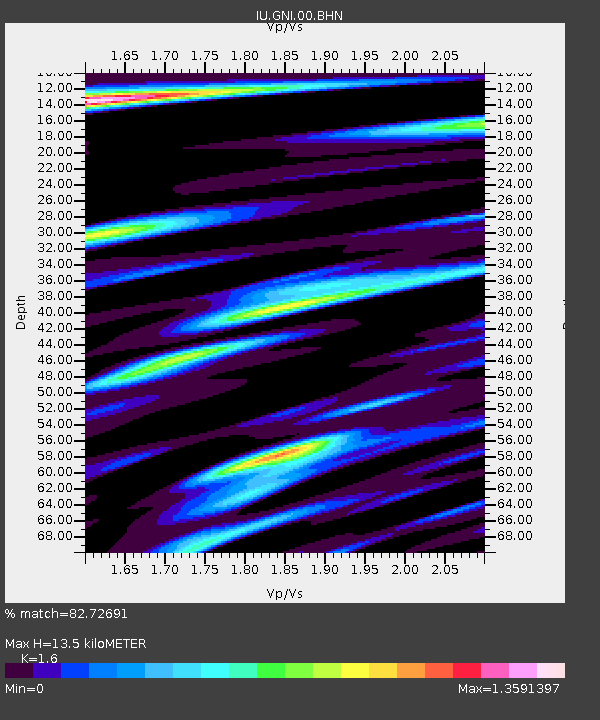
GNI Garni, Armenia - Earthquake Result Viewer
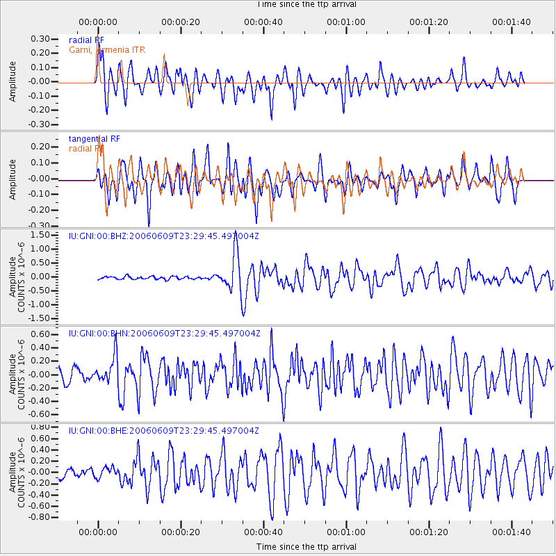
Earthquake location: Prince Edward Islands Region
Earthquake latitude/longitude: -47.8/32.6
Earthquake time(UTC): 2006/06/09 (160) 23:17:27 GMT
Earthquake Depth: 22 km
Earthquake Magnitude: 5.6 MB, 5.8 MS, 5.9 MW, 5.7 MW
Earthquake Catalog/Contributor: WHDF/NEIC
Network: IU Global Seismograph Network (GSN - IRIS/USGS)
Station: GNI Garni, Armenia
Lat/Lon: 40.15 N/44.74 E
Elevation: 1609 m
Distance: 88.2 deg
Az: 9.273 deg
Baz: 188.156 deg
Ray Param: 0.042757142
Estimated Moho Depth: 13.5 km
Estimated Crust Vp/Vs: 1.60
Assumed Crust Vp: 6.291 km/s
Estimated Crust Vs: 3.932 km/s
Estimated Crust Poisson's Ratio: 0.18
Radial Match: 82.72691 %
Radial Bump: 400
Transverse Match: 85.28072 %
Transverse Bump: 400
SOD ConfigId: 2669
Insert Time: 2010-03-03 13:48:03.848 +0000
GWidth: 2.5
Max Bumps: 400
Tol: 0.001

Signal To Noise

ChannelStoNSTALTA
IU:GNI:00:BHN:20060609T23:29:45.497004Z3.08435752.1126968E-76.8497144E-8
IU:GNI:00:BHE:20060609T23:29:45.497004Z1.30916929.331043E-87.127454E-8
IU:GNI:00:BHZ:20060609T23:29:45.497004Z14.2618847.051223E-74.9441034E-8
Arrivals
Ps1.3 SECOND
PpPs5.5 SECOND
PsPs/PpSs6.8 SECOND