You are here: Home > Network List > IU - Global Seismograph Network (GSN - IRIS/USGS) Stations List
> Station GNI Garni, Armenia > Earthquake Result Viewer
GNI Garni, Armenia - Earthquake Result Viewer

| Earthquake location: |
Eastern Siberia, Russia |
| Earthquake latitude/longitude: |
61.4/167.5 |
| Earthquake time(UTC): |
2006/04/21 (111) 11:14:15 GMT |
| Earthquake Depth: |
12 km |
| Earthquake Magnitude: |
5.8 MB, 5.8 MS, 6.1 MW, 6.1 MW |
| Earthquake Catalog/Contributor: |
WHDF/NEIC |
|
| Network: |
IU Global Seismograph Network (GSN - IRIS/USGS) |
| Station: |
GNI Garni, Armenia |
| Lat/Lon: |
40.15 N/44.74 E |
| Elevation: |
1609 m |
|
| Distance: |
68.7 deg |
| Az: |
316.249 deg |
| Baz: |
25.768 deg |
| Ray Param: |
0.056108035 |
| Estimated Moho Depth: |
68.0 km |
| Estimated Crust Vp/Vs: |
1.71 |
| Assumed Crust Vp: |
6.291 km/s |
| Estimated Crust Vs: |
3.679 km/s |
| Estimated Crust Poisson's Ratio: |
0.24 |
|
| Radial Match: |
83.04206 % |
| Radial Bump: |
400 |
| Transverse Match: |
77.05425 % |
| Transverse Bump: |
400 |
| SOD ConfigId: |
2669 |
| Insert Time: |
2010-03-03 13:48:07.898 +0000 |
| GWidth: |
2.5 |
| Max Bumps: |
400 |
| Tol: |
0.001 |
|
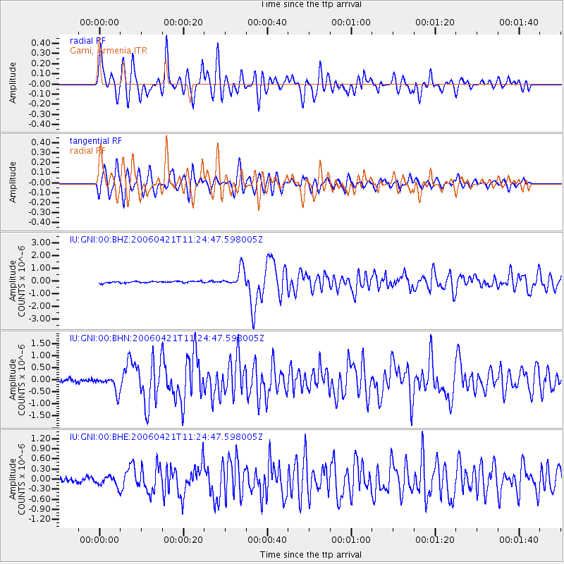
Signal To Noise
| Channel | StoN | STA | LTA |
| IU:GNI:00:BHN:20060421T11:24:47.598005Z | 4.691797 | 3.3652373E-7 | 7.1725985E-8 |
| IU:GNI:00:BHE:20060421T11:24:47.598005Z | 2.7400951 | 1.4750695E-7 | 5.383279E-8 |
| IU:GNI:00:BHZ:20060421T11:24:47.598005Z | 12.332403 | 7.45647E-7 | 6.046242E-8 |
| Arrivals |
| Ps | 8.0 SECOND |
| PpPs | 28 SECOND |
| PsPs/PpSs | 36 SECOND |


