You are here: Home > Network List > TA - USArray Transportable Network (new EarthScope stations) Stations List
> Station MDND Maddock, ND, USA > Earthquake Result Viewer
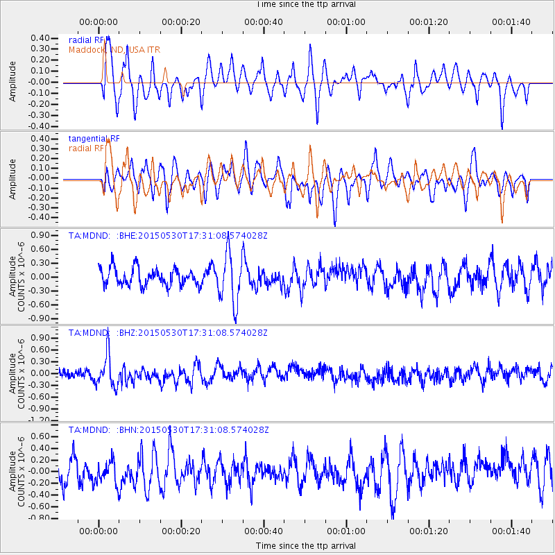
MDND Maddock, ND, USA - Earthquake Result Viewer
*The percent match for this event was below the threshold and hence no stack was calculated.
| Earthquake location: |
Tonga Islands |
| Earthquake latitude/longitude: |
-15.7/-173.3 |
| Earthquake time(UTC): |
2015/05/30 (150) 17:18:39 GMT |
| Earthquake Depth: |
51 km |
| Earthquake Magnitude: |
5.8 MB |
| Earthquake Catalog/Contributor: |
NEIC PDE/NEIC COMCAT |
|
| Network: |
TA USArray Transportable Network (new EarthScope stations) |
| Station: |
MDND Maddock, ND, USA |
| Lat/Lon: |
47.85 N/99.60 W |
| Elevation: |
479 m |
|
| Distance: |
91.0 deg |
| Az: |
40.29 deg |
| Baz: |
247.595 deg |
| Ray Param: |
$rayparam |
*The percent match for this event was below the threshold and hence was not used in the summary stack. |
|
| Radial Match: |
63.209316 % |
| Radial Bump: |
400 |
| Transverse Match: |
52.028137 % |
| Transverse Bump: |
400 |
| SOD ConfigId: |
7422571 |
| Insert Time: |
2019-04-19 03:31:04.364 +0000 |
| GWidth: |
2.5 |
| Max Bumps: |
400 |
| Tol: |
0.001 |
|
Signal To Noise
| Channel | StoN | STA | LTA |
| TA:MDND: :BHZ:20150530T17:31:08.574028Z | 4.7289534 | 4.2439981E-7 | 8.974497E-8 |
| TA:MDND: :BHN:20150530T17:31:08.574028Z | 0.8884497 | 2.0578689E-7 | 2.316247E-7 |
| TA:MDND: :BHE:20150530T17:31:08.574028Z | 2.6896179 | 5.0498403E-7 | 1.8775307E-7 |
| Arrivals |
| Ps | |
| PpPs | |
| PsPs/PpSs | |


