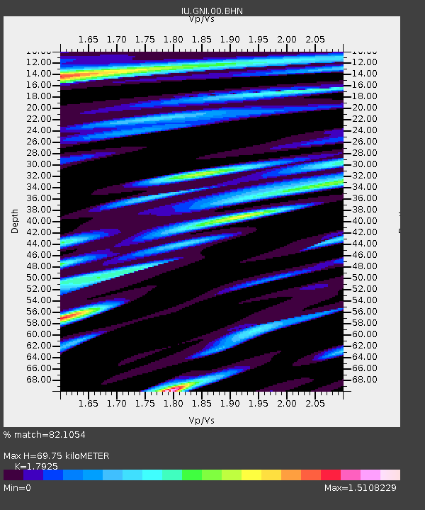
GNI Garni, Armenia - Earthquake Result Viewer

Earthquake location: Off W Coast Of Northern Sumatra
Earthquake latitude/longitude: 2.7/93.2
Earthquake time(UTC): 2006/04/19 (109) 20:36:48 GMT
Earthquake Depth: 30 km
Earthquake Magnitude: 5.5 MB, 5.7 MS, 6.2 MW, 6.2 MW
Earthquake Catalog/Contributor: WHDF/NEIC
Network: IU Global Seismograph Network (GSN - IRIS/USGS)
Station: GNI Garni, Armenia
Lat/Lon: 40.15 N/44.74 E
Elevation: 1609 m
Distance: 57.5 deg
Az: 317.119 deg
Baz: 117.524 deg
Ray Param: 0.06338221
Estimated Moho Depth: 69.75 km
Estimated Crust Vp/Vs: 1.79
Assumed Crust Vp: 6.291 km/s
Estimated Crust Vs: 3.509 km/s
Estimated Crust Poisson's Ratio: 0.27
Radial Match: 82.1054 %
Radial Bump: 400
Transverse Match: 75.8898 %
Transverse Bump: 400
SOD ConfigId: 2669
Insert Time: 2010-03-03 13:48:13.703 +0000
GWidth: 2.5
Max Bumps: 400
Tol: 0.001

Signal To Noise

ChannelStoNSTALTA
IU:GNI:00:BHN:20060419T20:46:04.098005Z1.9096111.11372046E-75.8321852E-8
IU:GNI:00:BHE:20060419T20:46:04.098005Z2.9880561.8951619E-76.342458E-8
IU:GNI:00:BHZ:20060419T20:46:04.098005Z8.8870273.8326104E-74.31259E-8
Arrivals
Ps9.2 SECOND
PpPs30 SECOND
PsPs/PpSs39 SECOND