You are here: Home > Network List > TA - USArray Transportable Network (new EarthScope stations) Stations List
> Station O03E Paynes Creek, CA, USA > Earthquake Result Viewer
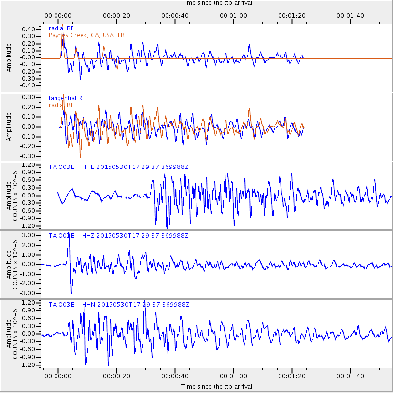
O03E Paynes Creek, CA, USA - Earthquake Result Viewer
*The percent match for this event was below the threshold and hence no stack was calculated.
| Earthquake location: |
Tonga Islands |
| Earthquake latitude/longitude: |
-15.7/-173.3 |
| Earthquake time(UTC): |
2015/05/30 (150) 17:18:39 GMT |
| Earthquake Depth: |
51 km |
| Earthquake Magnitude: |
5.8 MB |
| Earthquake Catalog/Contributor: |
NEIC PDE/NEIC COMCAT |
|
| Network: |
TA USArray Transportable Network (new EarthScope stations) |
| Station: |
O03E Paynes Creek, CA, USA |
| Lat/Lon: |
40.29 N/121.80 W |
| Elevation: |
967 m |
|
| Distance: |
73.5 deg |
| Az: |
38.653 deg |
| Baz: |
231.849 deg |
| Ray Param: |
$rayparam |
*The percent match for this event was below the threshold and hence was not used in the summary stack. |
|
| Radial Match: |
83.33886 % |
| Radial Bump: |
400 |
| Transverse Match: |
82.95587 % |
| Transverse Bump: |
400 |
| SOD ConfigId: |
7422571 |
| Insert Time: |
2019-04-19 03:31:08.956 +0000 |
| GWidth: |
2.5 |
| Max Bumps: |
400 |
| Tol: |
0.001 |
|
Signal To Noise
| Channel | StoN | STA | LTA |
| TA:O03E: :HHZ:20150530T17:29:37.369988Z | 10.429605 | 1.3024502E-6 | 1.248801E-7 |
| TA:O03E: :HHN:20150530T17:29:37.369988Z | 1.6574858 | 1.6782938E-7 | 1.0125539E-7 |
| TA:O03E: :HHE:20150530T17:29:37.369988Z | 1.8540896 | 2.356493E-7 | 1.2709702E-7 |
| Arrivals |
| Ps | |
| PpPs | |
| PsPs/PpSs | |


