You are here: Home > Network List > TA - USArray Transportable Network (new EarthScope stations) Stations List
> Station Z41A Richland Creek Farm, El Dorado, AR, USA > Earthquake Result Viewer
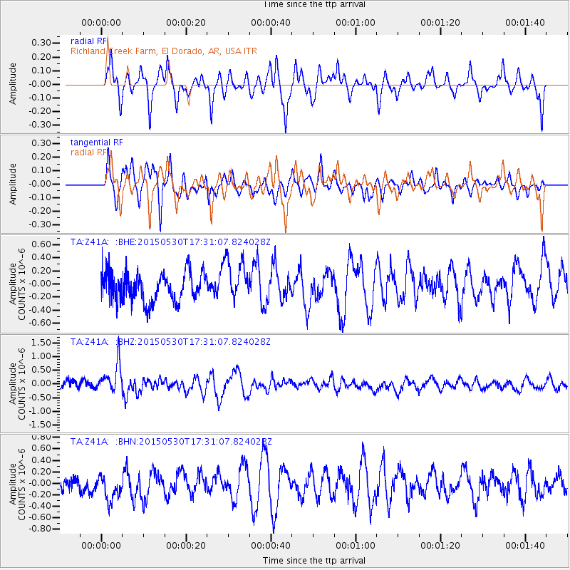
Z41A Richland Creek Farm, El Dorado, AR, USA - Earthquake Result Viewer
*The percent match for this event was below the threshold and hence no stack was calculated.
| Earthquake location: |
Tonga Islands |
| Earthquake latitude/longitude: |
-15.7/-173.3 |
| Earthquake time(UTC): |
2015/05/30 (150) 17:18:39 GMT |
| Earthquake Depth: |
51 km |
| Earthquake Magnitude: |
5.8 MB |
| Earthquake Catalog/Contributor: |
NEIC PDE/NEIC COMCAT |
|
| Network: |
TA USArray Transportable Network (new EarthScope stations) |
| Station: |
Z41A Richland Creek Farm, El Dorado, AR, USA |
| Lat/Lon: |
33.26 N/92.80 W |
| Elevation: |
62 m |
|
| Distance: |
90.8 deg |
| Az: |
55.744 deg |
| Baz: |
251.792 deg |
| Ray Param: |
$rayparam |
*The percent match for this event was below the threshold and hence was not used in the summary stack. |
|
| Radial Match: |
66.85745 % |
| Radial Bump: |
369 |
| Transverse Match: |
53.396915 % |
| Transverse Bump: |
369 |
| SOD ConfigId: |
7422571 |
| Insert Time: |
2019-04-19 03:31:21.945 +0000 |
| GWidth: |
2.5 |
| Max Bumps: |
400 |
| Tol: |
0.001 |
|
Signal To Noise
| Channel | StoN | STA | LTA |
| TA:Z41A: :BHZ:20150530T17:31:07.824028Z | 3.4090083 | 5.815128E-7 | 1.705812E-7 |
| TA:Z41A: :BHN:20150530T17:31:07.824028Z | 1.2865171 | 2.648847E-7 | 2.0589287E-7 |
| TA:Z41A: :BHE:20150530T17:31:07.824028Z | 1.5091883 | 3.2545324E-7 | 2.1564787E-7 |
| Arrivals |
| Ps | |
| PpPs | |
| PsPs/PpSs | |


