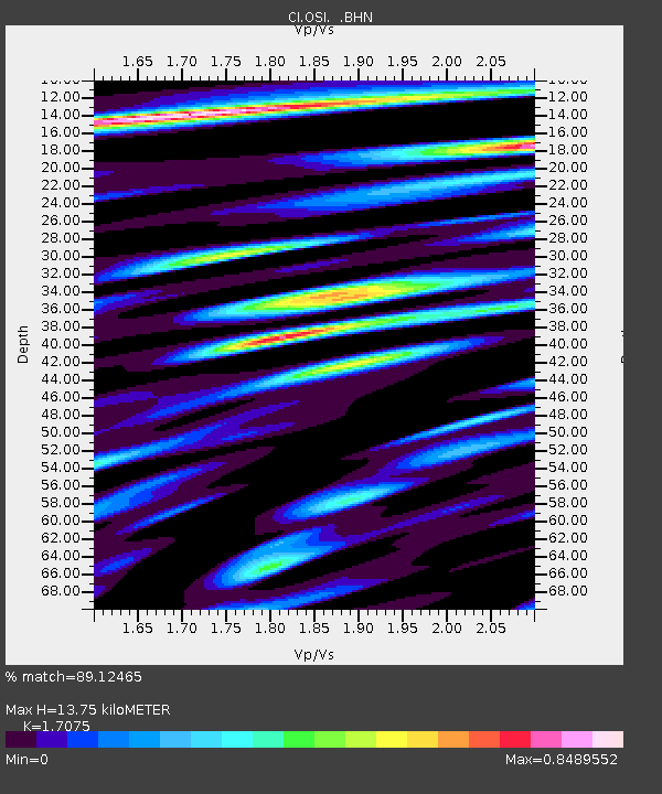
OSI Osito Audit - Earthquake Result Viewer

Earthquake location: Bonin Islands, Japan Region
Earthquake latitude/longitude: 28.9/139.3
Earthquake time(UTC): 1998/08/20 (232) 06:40:55 GMT
Earthquake Depth: 441 km
Earthquake Magnitude: 6.1 MB, 7.0 UNKNOWN, 7.0 MW
Earthquake Catalog/Contributor: WHDF/NEIC
Network: CI Caltech Regional Seismic Network
Station: OSI Osito Audit
Lat/Lon: 34.61 N/118.72 W
Elevation: 718 m
Distance: 83.0 deg
Az: 54.393 deg
Baz: 300.222 deg
Ray Param: 0.04530148
Estimated Moho Depth: 13.75 km
Estimated Crust Vp/Vs: 1.71
Assumed Crust Vp: 6.1 km/s
Estimated Crust Vs: 3.572 km/s
Estimated Crust Poisson's Ratio: 0.24
Radial Match: 89.12465 %
Radial Bump: 400
Transverse Match: 87.581406 %
Transverse Bump: 400
SOD ConfigId: 4770
Insert Time: 2010-02-25 21:28:03.400 +0000
GWidth: 2.5
Max Bumps: 400
Tol: 0.001

Signal To Noise

ChannelStoNSTALTA
CI:OSI: :BHN:19980820T06:52:02.169995Z1.00035041.9467366E-71.9460549E-7
CI:OSI: :BHE:19980820T06:52:02.169995Z1.39624392.7535293E-71.9720974E-7
CI:OSI: :BHZ:19980820T06:52:02.169995Z1.45495894.994808E-73.4329548E-7
Arrivals
Ps1.6 SECOND
PpPs6.0 SECOND
PsPs/PpSs7.6 SECOND