You are here: Home > Network List > IU - Global Seismograph Network (GSN - IRIS/USGS) Stations List
> Station GNI Garni, Armenia > Earthquake Result Viewer
GNI Garni, Armenia - Earthquake Result Viewer
| Earthquake location: |
Banda Sea |
| Earthquake latitude/longitude: |
-4.1/127.4 |
| Earthquake time(UTC): |
2000/08/28 (241) 15:05:47 GMT |
| Earthquake Depth: |
16 km |
| Earthquake Magnitude: |
6.5 MB, 6.8 MS, 6.8 MW, 6.7 ME |
| Earthquake Catalog/Contributor: |
WHDF/NEIC |
|
| Network: |
IU Global Seismograph Network (GSN - IRIS/USGS) |
| Station: |
GNI Garni, Armenia |
| Lat/Lon: |
40.15 N/44.74 E |
| Elevation: |
1609 m |
|
| Distance: |
87.0 deg |
| Az: |
310.426 deg |
| Baz: |
97.856 deg |
| Ray Param: |
0.043618806 |
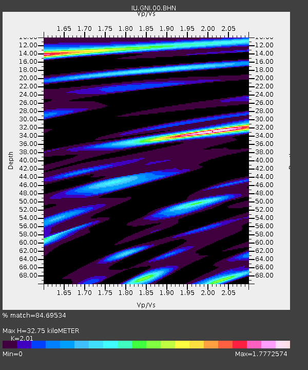
| Estimated Moho Depth: |
32.75 km |
| Estimated Crust Vp/Vs: |
2.01 |
| Assumed Crust Vp: |
6.291 km/s |
| Estimated Crust Vs: |
3.13 km/s |
| Estimated Crust Poisson's Ratio: |
0.34 |
|
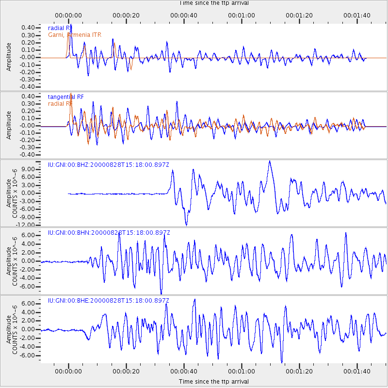
| Radial Match: |
84.69534 % |
| Radial Bump: |
400 |
| Transverse Match: |
79.37552 % |
| Transverse Bump: |
400 |
| SOD ConfigId: |
3744 |
| Insert Time: |
2010-03-03 13:48:38.687 +0000 |
| GWidth: |
2.5 |
| Max Bumps: |
400 |
| Tol: |
0.001 |
|
Signal To Noise
| Channel | StoN | STA | LTA |
| IU:GNI:00:BHN:20000828T15:18:00.897Z | 0.9450596 | 8.0328086E-8 | 8.499791E-8 |
| IU:GNI:00:BHE:20000828T15:18:00.897Z | 0.7805228 | 6.8721036E-8 | 8.8044885E-8 |
| IU:GNI:00:BHZ:20000828T15:18:00.897Z | 4.544476 | 3.310022E-7 | 7.2836166E-8 |
| Arrivals |
| Ps | 5.4 SECOND |
| PpPs | 15 SECOND |
| PsPs/PpSs | 21 SECOND |


