You are here: Home > Network List > IU - Global Seismograph Network (GSN - IRIS/USGS) Stations List
> Station GNI Garni, Armenia > Earthquake Result Viewer
GNI Garni, Armenia - Earthquake Result Viewer
| Earthquake location: |
South Indian Ocean |
| Earthquake latitude/longitude: |
-13.8/97.5 |
| Earthquake time(UTC): |
2000/06/18 (170) 14:44:13 GMT |
| Earthquake Depth: |
10 km |
| Earthquake Magnitude: |
6.8 MB, 7.8 MS, 7.8 MW, 7.6 MW |
| Earthquake Catalog/Contributor: |
WHDF/NEIC |
|
| Network: |
IU Global Seismograph Network (GSN - IRIS/USGS) |
| Station: |
GNI Garni, Armenia |
| Lat/Lon: |
40.15 N/44.74 E |
| Elevation: |
1609 m |
|
| Distance: |
72.6 deg |
| Az: |
320.279 deg |
| Baz: |
125.909 deg |
| Ray Param: |
0.05354767 |
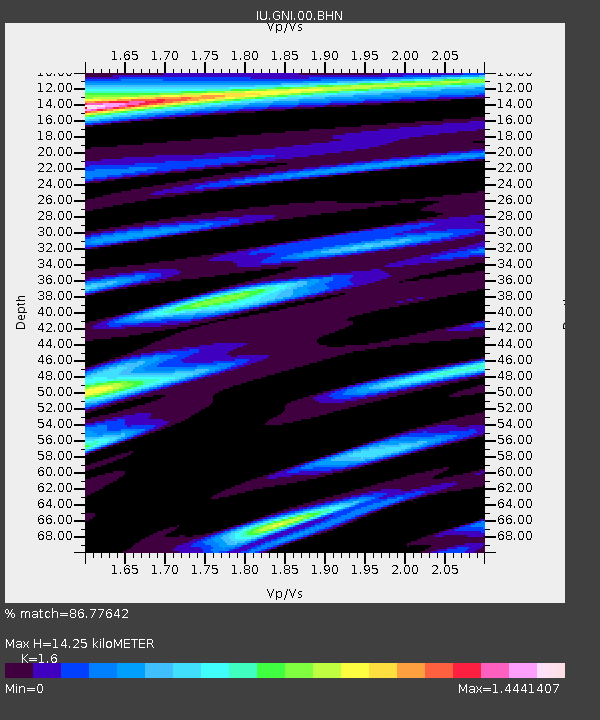
| Estimated Moho Depth: |
14.25 km |
| Estimated Crust Vp/Vs: |
1.60 |
| Assumed Crust Vp: |
6.291 km/s |
| Estimated Crust Vs: |
3.932 km/s |
| Estimated Crust Poisson's Ratio: |
0.18 |
|
| Radial Match: |
86.77642 % |
| Radial Bump: |
400 |
| Transverse Match: |
78.049 % |
| Transverse Bump: |
400 |
| SOD ConfigId: |
3744 |
| Insert Time: |
2010-03-03 13:48:42.293 +0000 |
| GWidth: |
2.5 |
| Max Bumps: |
400 |
| Tol: |
0.001 |
|
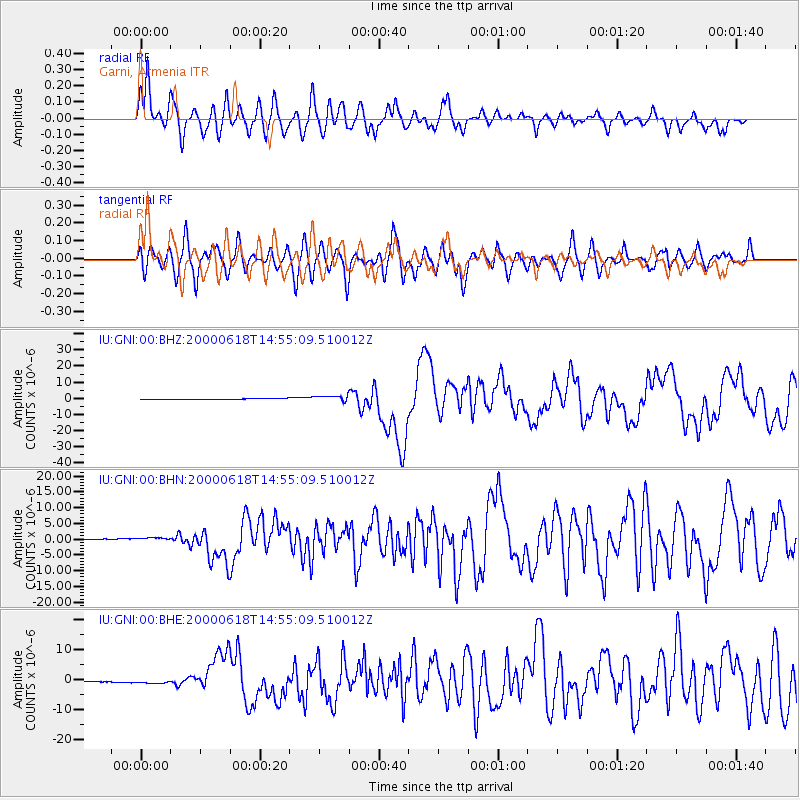
Signal To Noise
| Channel | StoN | STA | LTA |
| IU:GNI:00:BHN:20000618T14:55:09.510012Z | 4.4442782 | 5.3688893E-7 | 1.2080451E-7 |
| IU:GNI:00:BHE:20000618T14:55:09.510012Z | 4.3996277 | 7.297208E-7 | 1.6585967E-7 |
| IU:GNI:00:BHZ:20000618T14:55:09.510012Z | 5.10407 | 1.7814086E-6 | 3.4901728E-7 |
| Arrivals |
| Ps | 1.4 SECOND |
| PpPs | 5.7 SECOND |
| PsPs/PpSs | 7.1 SECOND |


