You are here: Home > Network List > CI - Caltech Regional Seismic Network Stations List
> Station OSI Osito Audit > Earthquake Result Viewer
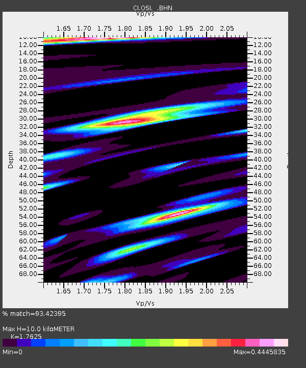
OSI Osito Audit - Earthquake Result Viewer
| Earthquake location: |
Fiji Islands Region |
| Earthquake latitude/longitude: |
-21.6/-176.4 |
| Earthquake time(UTC): |
1998/12/27 (361) 00:38:26 GMT |
| Earthquake Depth: |
144 km |
| Earthquake Magnitude: |
6.1 MB, 6.9 UNKNOWN, 6.6 ME |
| Earthquake Catalog/Contributor: |
WHDF/NEIC |
|
| Network: |
CI Caltech Regional Seismic Network |
| Station: |
OSI Osito Audit |
| Lat/Lon: |
34.61 N/118.72 W |
| Elevation: |
718 m |
|
| Distance: |
78.3 deg |
| Az: |
45.369 deg |
| Baz: |
233.399 deg |
| Ray Param: |
0.049409814 |
| Estimated Moho Depth: |
10.0 km |
| Estimated Crust Vp/Vs: |
1.76 |
| Assumed Crust Vp: |
6.1 km/s |
| Estimated Crust Vs: |
3.461 km/s |
| Estimated Crust Poisson's Ratio: |
0.26 |
|
| Radial Match: |
93.42395 % |
| Radial Bump: |
400 |
| Transverse Match: |
93.39865 % |
| Transverse Bump: |
400 |
| SOD ConfigId: |
4770 |
| Insert Time: |
2010-02-25 21:28:04.876 +0000 |
| GWidth: |
2.5 |
| Max Bumps: |
400 |
| Tol: |
0.001 |
|

Signal To Noise
| Channel | StoN | STA | LTA |
| CI:OSI: :BHN:19981227T00:49:39.611011Z | 1.1669083 | 2.8943765E-7 | 2.4803805E-7 |
| CI:OSI: :BHE:19981227T00:49:39.611011Z | 1.9304749 | 6.399312E-9 | 3.3148901E-9 |
| CI:OSI: :BHZ:19981227T00:49:39.611011Z | 3.614082 | 9.763603E-7 | 2.7015443E-7 |
| Arrivals |
| Ps | 1.3 SECOND |
| PpPs | 4.4 SECOND |
| PsPs/PpSs | 5.7 SECOND |


