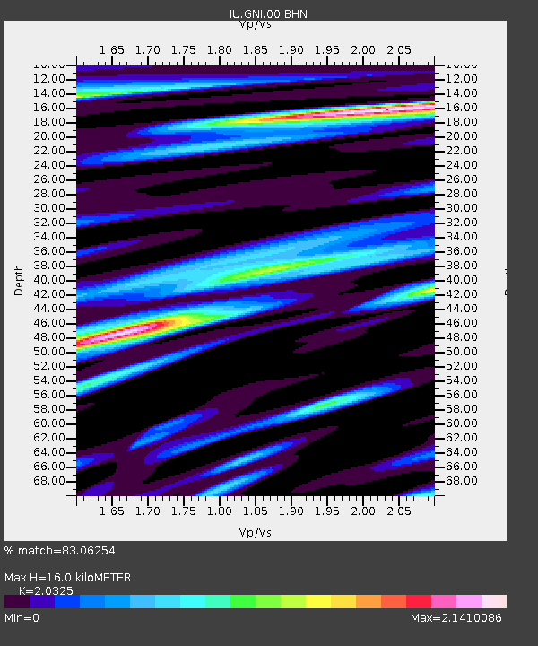
GNI Garni, Armenia - Earthquake Result Viewer

Earthquake location: Mauritius - Reunion Region
Earthquake latitude/longitude: -18.0/65.5
Earthquake time(UTC): 2000/04/07 (098) 19:08:27 GMT
Earthquake Depth: 10 km
Earthquake Magnitude: 5.5 MB, 5.9 MS, 6.3 MW, 6.2 MW
Earthquake Catalog/Contributor: WHDF/NEIC
Network: IU Global Seismograph Network (GSN - IRIS/USGS)
Station: GNI Garni, Armenia
Lat/Lon: 40.15 N/44.74 E
Elevation: 1609 m
Distance: 61.0 deg
Az: 341.897 deg
Baz: 157.313 deg
Ray Param: 0.061130937
Estimated Moho Depth: 16.0 km
Estimated Crust Vp/Vs: 2.03
Assumed Crust Vp: 6.291 km/s
Estimated Crust Vs: 3.095 km/s
Estimated Crust Poisson's Ratio: 0.34
Radial Match: 83.06254 %
Radial Bump: 400
Transverse Match: 85.03511 %
Transverse Bump: 400
SOD ConfigId: 3744
Insert Time: 2010-03-03 13:48:59.550 +0000
GWidth: 2.5
Max Bumps: 400
Tol: 0.001

Signal To Noise

ChannelStoNSTALTA
IU:GNI:00:BHN:20000407T19:18:10.509016Z0.74066668.856632E-81.195765E-7
IU:GNI:00:BHE:20000407T19:18:10.509016Z0.76073878.0984016E-81.0645445E-7
IU:GNI:00:BHZ:20000407T19:18:10.509016Z1.24835571.196468E-79.5843504E-8
Arrivals
Ps2.7 SECOND
PpPs7.4 SECOND
PsPs/PpSs10 SECOND