You are here: Home > Network List > IU - Global Seismograph Network (GSN - IRIS/USGS) Stations List
> Station GNI Garni, Armenia > Earthquake Result Viewer
GNI Garni, Armenia - Earthquake Result Viewer
| Earthquake location: |
Western Honshu, Japan |
| Earthquake latitude/longitude: |
35.5/133.1 |
| Earthquake time(UTC): |
2000/10/06 (280) 04:30:19 GMT |
| Earthquake Depth: |
10 km |
| Earthquake Magnitude: |
5.8 MB, 6.8 MS, 7.0 ME, 6.7 MW |
| Earthquake Catalog/Contributor: |
WHDF/NEIC |
|
| Network: |
IU Global Seismograph Network (GSN - IRIS/USGS) |
| Station: |
GNI Garni, Armenia |
| Lat/Lon: |
40.15 N/44.74 E |
| Elevation: |
1609 m |
|
| Distance: |
67.1 deg |
| Az: |
303.747 deg |
| Baz: |
62.327 deg |
| Ray Param: |
0.05714874 |
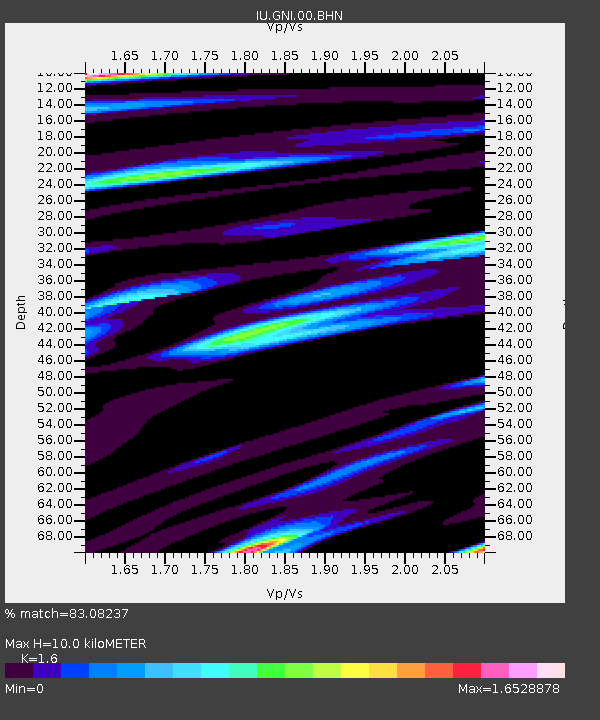
| Estimated Moho Depth: |
10.0 km |
| Estimated Crust Vp/Vs: |
1.60 |
| Assumed Crust Vp: |
6.291 km/s |
| Estimated Crust Vs: |
3.932 km/s |
| Estimated Crust Poisson's Ratio: |
0.18 |
|
| Radial Match: |
83.08237 % |
| Radial Bump: |
400 |
| Transverse Match: |
79.100266 % |
| Transverse Bump: |
400 |
| SOD ConfigId: |
3744 |
| Insert Time: |
2010-03-03 13:49:07.385 +0000 |
| GWidth: |
2.5 |
| Max Bumps: |
400 |
| Tol: |
0.001 |
|
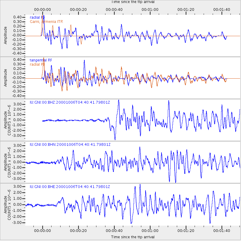
Signal To Noise
| Channel | StoN | STA | LTA |
| IU:GNI:00:BHN:20001006T04:40:41.79801Z | 0.9408832 | 6.8330245E-8 | 7.2623514E-8 |
| IU:GNI:00:BHE:20001006T04:40:41.79801Z | 0.6710657 | 6.944851E-8 | 1.0348988E-7 |
| IU:GNI:00:BHZ:20001006T04:40:41.79801Z | 2.1769078 | 1.4181381E-7 | 6.514462E-8 |
| Arrivals |
| Ps | 1.0 SECOND |
| PpPs | 4.0 SECOND |
| PsPs/PpSs | 5.0 SECOND |


