You are here: Home > Network List > IU - Global Seismograph Network (GSN - IRIS/USGS) Stations List
> Station GNI Garni, Armenia > Earthquake Result Viewer
GNI Garni, Armenia - Earthquake Result Viewer
| Earthquake location: |
Bonin Islands, Japan Region |
| Earthquake latitude/longitude: |
28.9/139.6 |
| Earthquake time(UTC): |
2000/08/06 (219) 07:27:12 GMT |
| Earthquake Depth: |
395 km |
| Earthquake Magnitude: |
6.3 MB, 7.3 MW, 7.3 MW |
| Earthquake Catalog/Contributor: |
WHDF/NEIC |
|
| Network: |
IU Global Seismograph Network (GSN - IRIS/USGS) |
| Station: |
GNI Garni, Armenia |
| Lat/Lon: |
40.15 N/44.74 E |
| Elevation: |
1609 m |
|
| Distance: |
75.4 deg |
| Az: |
307.884 deg |
| Baz: |
64.586 deg |
| Ray Param: |
0.050534714 |
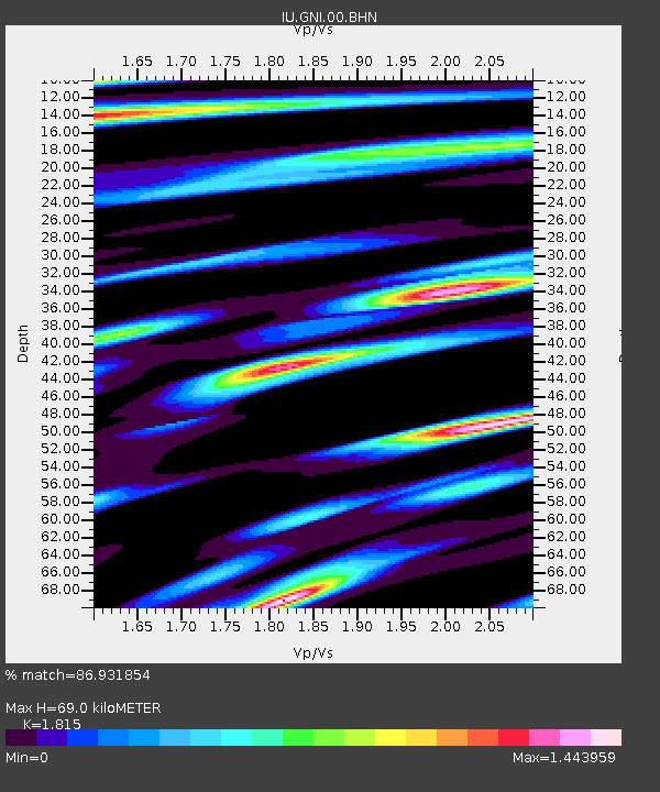
| Estimated Moho Depth: |
69.0 km |
| Estimated Crust Vp/Vs: |
1.82 |
| Assumed Crust Vp: |
6.291 km/s |
| Estimated Crust Vs: |
3.466 km/s |
| Estimated Crust Poisson's Ratio: |
0.28 |
|
| Radial Match: |
86.931854 % |
| Radial Bump: |
400 |
| Transverse Match: |
69.4789 % |
| Transverse Bump: |
400 |
| SOD ConfigId: |
3744 |
| Insert Time: |
2010-03-03 13:49:13.260 +0000 |
| GWidth: |
2.5 |
| Max Bumps: |
400 |
| Tol: |
0.001 |
|
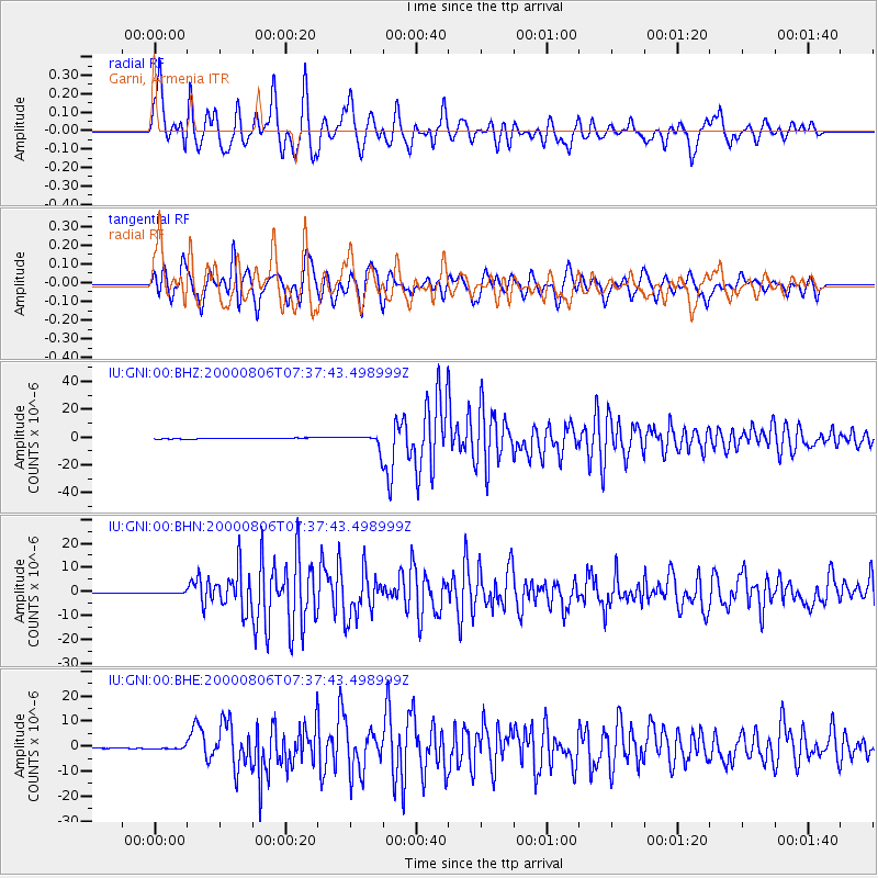
Signal To Noise
| Channel | StoN | STA | LTA |
| IU:GNI:00:BHN:20000806T07:37:43.498999Z | 2.9330552 | 2.518526E-7 | 8.5866986E-8 |
| IU:GNI:00:BHE:20000806T07:37:43.498999Z | 2.7145998 | 4.5066622E-7 | 1.6601572E-7 |
| IU:GNI:00:BHZ:20000806T07:37:43.498999Z | 16.399319 | 4.7438334E-6 | 2.8927016E-7 |
| Arrivals |
| Ps | 9.2 SECOND |
| PpPs | 30 SECOND |
| PsPs/PpSs | 39 SECOND |


