GNI Garni, Armenia - Earthquake Result Viewer
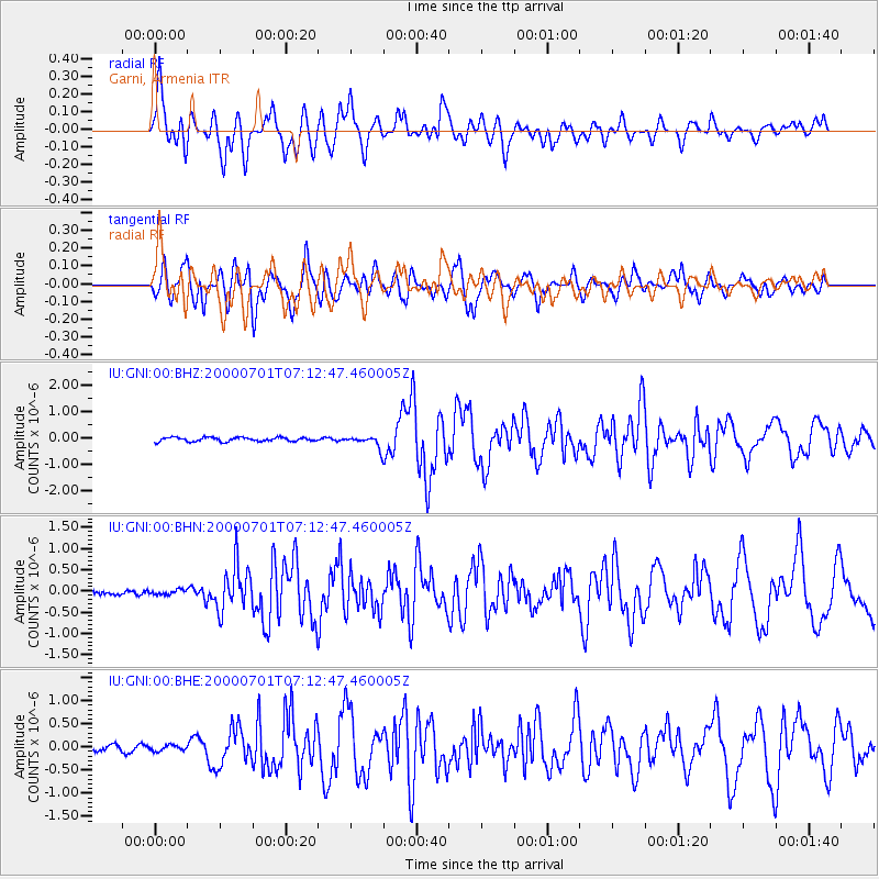
Earthquake location: Near S. Coast Of Honshu, Japan
Earthquake latitude/longitude: 34.2/139.1
Earthquake time(UTC): 2000/07/01 (183) 07:01:55 GMT
Earthquake Depth: 10 km
Earthquake Magnitude: 6.0 MB, 6.1 MS, 6.2 MW, 6.2 MW
Earthquake Catalog/Contributor: WHDF/NEIC
Network: IU Global Seismograph Network (GSN - IRIS/USGS)
Station: GNI Garni, Armenia
Lat/Lon: 40.15 N/44.74 E
Elevation: 1609 m
Distance: 71.9 deg
Az: 306.475 deg
Baz: 60.374 deg
Ray Param: 0.054028757
Estimated Moho Depth: 10.0 km
Estimated Crust Vp/Vs: 1.60
Assumed Crust Vp: 6.291 km/s
Estimated Crust Vs: 3.932 km/s
Estimated Crust Poisson's Ratio: 0.18
Radial Match: 87.432655 %
Radial Bump: 400
Transverse Match: 85.666794 %
Transverse Bump: 400
SOD ConfigId: 3744
Insert Time: 2010-03-03 13:49:26.124 +0000
GWidth: 2.5
Max Bumps: 400
Tol: 0.001

Signal To Noise

ChannelStoNSTALTA
IU:GNI:00:BHN:20000701T07:12:47.460005Z1.1643985.7916658E-84.9739576E-8
IU:GNI:00:BHE:20000701T07:12:47.460005Z0.99526666.6003544E-86.631745E-8
IU:GNI:00:BHZ:20000701T07:12:47.460005Z2.9842062.2260363E-77.459393E-8
Arrivals
Ps1.0 SECOND
PpPs4.0 SECOND
PsPs/PpSs5.0 SECOND