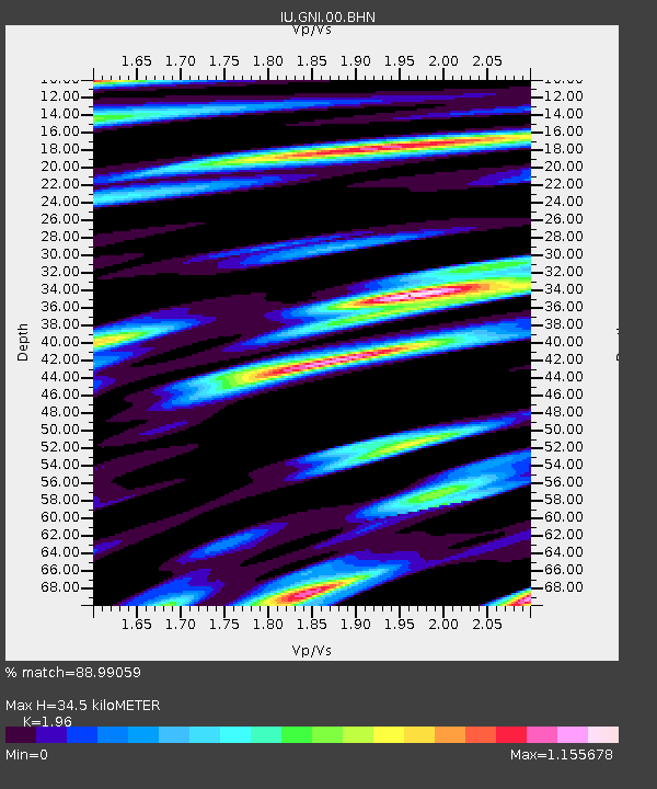
GNI Garni, Armenia - Earthquake Result Viewer
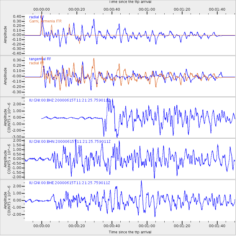
Earthquake location: Southeast Of Shikoku, Japan
Earthquake latitude/longitude: 29.4/132.1
Earthquake time(UTC): 2000/06/15 (167) 11:10:46 GMT
Earthquake Depth: 10 km
Earthquake Magnitude: 6.0 MB, 5.6 MS, 6.1 MW, 6.1 MW
Earthquake Catalog/Contributor: WHDF/NEIC
Network: IU Global Seismograph Network (GSN - IRIS/USGS)
Station: GNI Garni, Armenia
Lat/Lon: 40.15 N/44.74 E
Elevation: 1609 m
Distance: 69.9 deg
Az: 305.355 deg
Baz: 68.244 deg
Ray Param: 0.055369534
Estimated Moho Depth: 34.5 km
Estimated Crust Vp/Vs: 1.96
Assumed Crust Vp: 6.291 km/s
Estimated Crust Vs: 3.21 km/s
Estimated Crust Poisson's Ratio: 0.32
Radial Match: 88.99059 %
Radial Bump: 400
Transverse Match: 76.81502 %
Transverse Bump: 400
SOD ConfigId: 3744
Insert Time: 2010-03-03 13:49:31.663 +0000
GWidth: 2.5
Max Bumps: 400
Tol: 0.001

Signal To Noise

ChannelStoNSTALTA
IU:GNI:00:BHN:20000615T11:21:25.759011Z0.777521438.933317E-81.148948E-7
IU:GNI:00:BHE:20000615T11:21:25.759011Z0.311655643.7437804E-81.2012553E-7
IU:GNI:00:BHZ:20000615T11:21:25.759011Z1.3616631.1162431E-78.197646E-8
Arrivals
Ps5.4 SECOND
PpPs16 SECOND
PsPs/PpSs21 SECOND