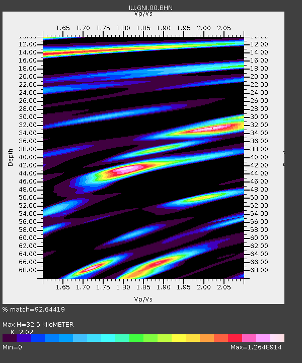
GNI Garni, Armenia - Earthquake Result Viewer
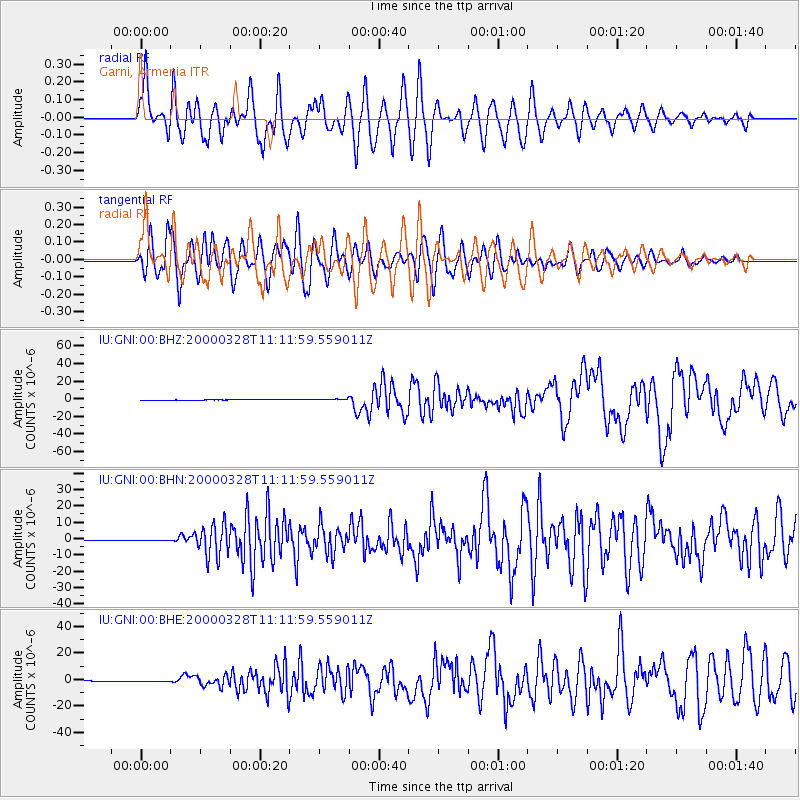
Earthquake location: Volcano Islands, Japan Region
Earthquake latitude/longitude: 22.3/143.7
Earthquake time(UTC): 2000/03/28 (088) 11:00:22 GMT
Earthquake Depth: 126 km
Earthquake Magnitude: 6.8 MB, 7.6 MS, 7.6 MW, 7.6 MW
Earthquake Catalog/Contributor: WHDF/NEIC
Network: IU Global Seismograph Network (GSN - IRIS/USGS)
Station: GNI Garni, Armenia
Lat/Lon: 40.15 N/44.74 E
Elevation: 1609 m
Distance: 82.4 deg
Az: 310.203 deg
Baz: 67.299 deg
Ray Param: 0.04661029
Estimated Moho Depth: 32.5 km
Estimated Crust Vp/Vs: 2.02
Assumed Crust Vp: 6.291 km/s
Estimated Crust Vs: 3.114 km/s
Estimated Crust Poisson's Ratio: 0.34
Radial Match: 92.64419 %
Radial Bump: 400
Transverse Match: 87.07138 %
Transverse Bump: 400
SOD ConfigId: 3744
Insert Time: 2010-03-03 13:49:40.071 +0000
GWidth: 2.5
Max Bumps: 400
Tol: 0.001

Signal To Noise

ChannelStoNSTALTA
IU:GNI:00:BHN:20000328T11:11:59.559011Z2.6171461.9848403E-77.583988E-8
IU:GNI:00:BHE:20000328T11:11:59.559011Z1.60853582.2305949E-71.3867239E-7
IU:GNI:00:BHZ:20000328T11:11:59.559011Z3.6641267.75137E-72.1154757E-7
Arrivals
Ps5.4 SECOND
PpPs15 SECOND
PsPs/PpSs21 SECOND