You are here: Home > Network List > IU - Global Seismograph Network (GSN - IRIS/USGS) Stations List
> Station GNI Garni, Armenia > Earthquake Result Viewer
GNI Garni, Armenia - Earthquake Result Viewer
| Earthquake location: |
Celebes Sea |
| Earthquake latitude/longitude: |
5.4/121.9 |
| Earthquake time(UTC): |
1999/03/04 (063) 08:52:01 GMT |
| Earthquake Depth: |
33 km |
| Earthquake Magnitude: |
6.4 MB, 6.5 MS, 7.1 MW, 7.1 MW |
| Earthquake Catalog/Contributor: |
WHDF/NEIC |
|
| Network: |
IU Global Seismograph Network (GSN - IRIS/USGS) |
| Station: |
GNI Garni, Armenia |
| Lat/Lon: |
40.15 N/44.74 E |
| Elevation: |
1609 m |
|
| Distance: |
76.8 deg |
| Az: |
309.836 deg |
| Baz: |
94.129 deg |
| Ray Param: |
0.050735645 |
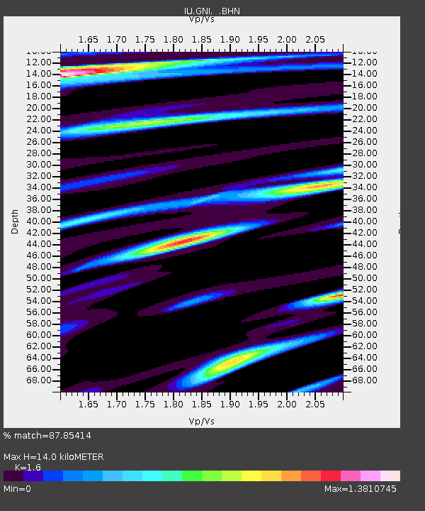
| Estimated Moho Depth: |
14.0 km |
| Estimated Crust Vp/Vs: |
1.60 |
| Assumed Crust Vp: |
6.291 km/s |
| Estimated Crust Vs: |
3.932 km/s |
| Estimated Crust Poisson's Ratio: |
0.18 |
|
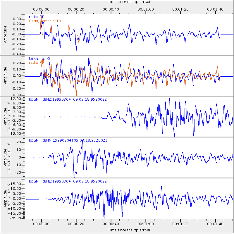
| Radial Match: |
87.85414 % |
| Radial Bump: |
400 |
| Transverse Match: |
83.069145 % |
| Transverse Bump: |
400 |
| SOD ConfigId: |
4480 |
| Insert Time: |
2010-03-03 13:49:51.492 +0000 |
| GWidth: |
2.5 |
| Max Bumps: |
400 |
| Tol: |
0.001 |
|
Signal To Noise
| Channel | StoN | STA | LTA |
| IU:GNI: :BHN:19990304T09:03:18.952002Z | 6.636605 | 8.072955E-7 | 1.2164286E-7 |
| IU:GNI: :BHE:19990304T09:03:18.952002Z | 1.3868169 | 1.5188492E-7 | 1.09520535E-7 |
| IU:GNI: :BHZ:19990304T09:03:18.952002Z | 1.3776729 | 1.09335076E-7 | 7.9362145E-8 |
| Arrivals |
| Ps | 1.4 SECOND |
| PpPs | 5.6 SECOND |
| PsPs/PpSs | 7.0 SECOND |


