You are here: Home > Network List > IU - Global Seismograph Network (GSN - IRIS/USGS) Stations List
> Station GNI Garni, Armenia > Earthquake Result Viewer
GNI Garni, Armenia - Earthquake Result Viewer
| Earthquake location: |
Kuril Islands |
| Earthquake latitude/longitude: |
45.4/151.6 |
| Earthquake time(UTC): |
1999/05/08 (128) 19:44:35 GMT |
| Earthquake Depth: |
63 km |
| Earthquake Magnitude: |
6.2 MB, 5.3 MS, 5.9 MW, 5.9 MW |
| Earthquake Catalog/Contributor: |
WHDF/NEIC |
|
| Network: |
IU Global Seismograph Network (GSN - IRIS/USGS) |
| Station: |
GNI Garni, Armenia |
| Lat/Lon: |
40.15 N/44.74 E |
| Elevation: |
1609 m |
|
| Distance: |
72.6 deg |
| Az: |
309.762 deg |
| Baz: |
44.907 deg |
| Ray Param: |
0.053436574 |
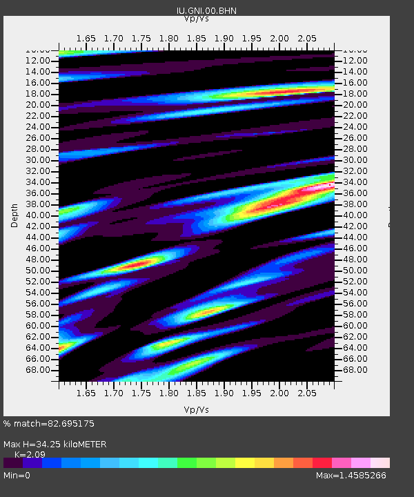
| Estimated Moho Depth: |
34.25 km |
| Estimated Crust Vp/Vs: |
2.09 |
| Assumed Crust Vp: |
6.291 km/s |
| Estimated Crust Vs: |
3.01 km/s |
| Estimated Crust Poisson's Ratio: |
0.35 |
|
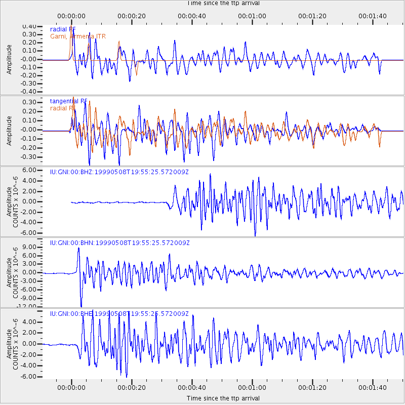
| Radial Match: |
82.695175 % |
| Radial Bump: |
400 |
| Transverse Match: |
81.54381 % |
| Transverse Bump: |
400 |
| SOD ConfigId: |
4480 |
| Insert Time: |
2010-03-03 13:49:58.439 +0000 |
| GWidth: |
2.5 |
| Max Bumps: |
400 |
| Tol: |
0.001 |
|
Signal To Noise
| Channel | StoN | STA | LTA |
| IU:GNI:00:BHN:19990508T19:55:25.572009Z | 73.69957 | 4.596797E-6 | 6.23721E-8 |
| IU:GNI:00:BHE:19990508T19:55:25.572009Z | 27.131813 | 1.6962821E-6 | 6.2520044E-8 |
| IU:GNI:00:BHZ:19990508T19:55:25.572009Z | 15.473598 | 1.1104033E-6 | 7.1761164E-8 |
| Arrivals |
| Ps | 6.1 SECOND |
| PpPs | 16 SECOND |
| PsPs/PpSs | 22 SECOND |


