You are here: Home > Network List > IU - Global Seismograph Network (GSN - IRIS/USGS) Stations List
> Station GNI Garni, Armenia > Earthquake Result Viewer
GNI Garni, Armenia - Earthquake Result Viewer
| Earthquake location: |
Ryukyu Islands, Japan |
| Earthquake latitude/longitude: |
25.7/126.2 |
| Earthquake time(UTC): |
2001/08/17 (229) 22:25:49 GMT |
| Earthquake Depth: |
33 km |
| Earthquake Magnitude: |
5.6 MB, 5.6 MS, 5.9 MW, 5.9 MW |
| Earthquake Catalog/Contributor: |
WHDF/NEIC |
|
| Network: |
IU Global Seismograph Network (GSN - IRIS/USGS) |
| Station: |
GNI Garni, Armenia |
| Lat/Lon: |
40.15 N/44.74 E |
| Elevation: |
1609 m |
|
| Distance: |
67.7 deg |
| Az: |
304.96 deg |
| Baz: |
74.636 deg |
| Ray Param: |
0.056767114 |
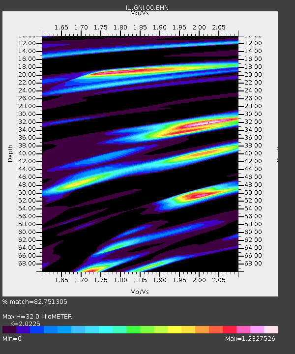
| Estimated Moho Depth: |
32.0 km |
| Estimated Crust Vp/Vs: |
2.02 |
| Assumed Crust Vp: |
6.291 km/s |
| Estimated Crust Vs: |
3.11 km/s |
| Estimated Crust Poisson's Ratio: |
0.34 |
|
| Radial Match: |
82.751305 % |
| Radial Bump: |
400 |
| Transverse Match: |
65.0749 % |
| Transverse Bump: |
400 |
| SOD ConfigId: |
20082 |
| Insert Time: |
2010-03-03 13:50:12.439 +0000 |
| GWidth: |
2.5 |
| Max Bumps: |
400 |
| Tol: |
0.001 |
|
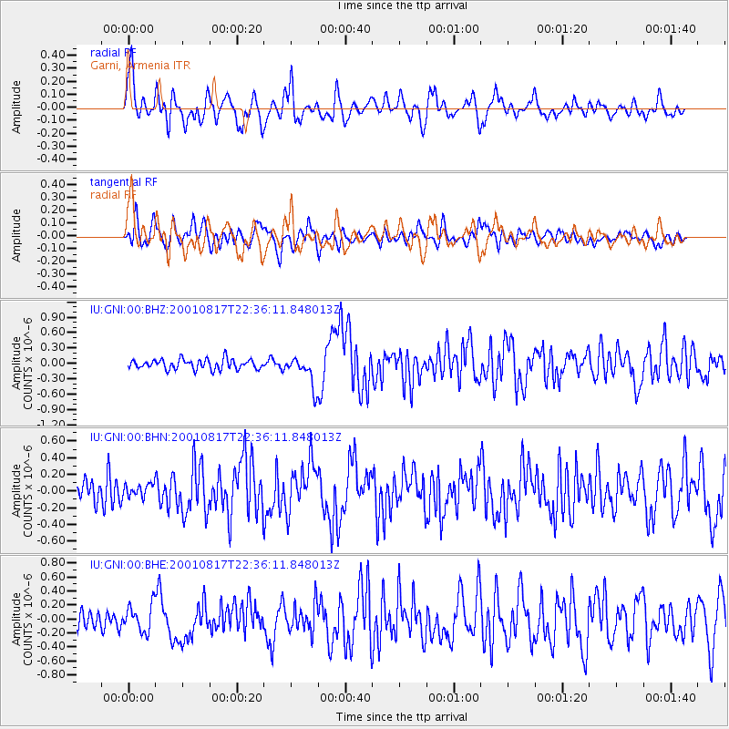
Signal To Noise
| Channel | StoN | STA | LTA |
| IU:GNI:00:BHN:20010817T22:36:11.848013Z | 0.7726408 | 7.75286E-8 | 1.00342355E-7 |
| IU:GNI:00:BHE:20010817T22:36:11.848013Z | 1.8316116 | 1.9769861E-7 | 1.0793697E-7 |
| IU:GNI:00:BHZ:20010817T22:36:11.848013Z | 3.0264597 | 2.9664207E-7 | 9.8016194E-8 |
| Arrivals |
| Ps | 5.4 SECOND |
| PpPs | 15 SECOND |
| PsPs/PpSs | 20 SECOND |


