You are here: Home > Network List > IU - Global Seismograph Network (GSN - IRIS/USGS) Stations List
> Station GNI Garni, Armenia > Earthquake Result Viewer
GNI Garni, Armenia - Earthquake Result Viewer
| Earthquake location: |
Hokkaido, Japan Region |
| Earthquake latitude/longitude: |
41.0/142.3 |
| Earthquake time(UTC): |
2001/08/13 (225) 20:11:23 GMT |
| Earthquake Depth: |
38 km |
| Earthquake Magnitude: |
6.0 MB, 6.3 MS, 6.4 MW, 6.3 ME |
| Earthquake Catalog/Contributor: |
WHDF/NEIC |
|
| Network: |
IU Global Seismograph Network (GSN - IRIS/USGS) |
| Station: |
GNI Garni, Armenia |
| Lat/Lon: |
40.15 N/44.74 E |
| Elevation: |
1609 m |
|
| Distance: |
69.9 deg |
| Az: |
305.987 deg |
| Baz: |
52.981 deg |
| Ray Param: |
0.05528026 |
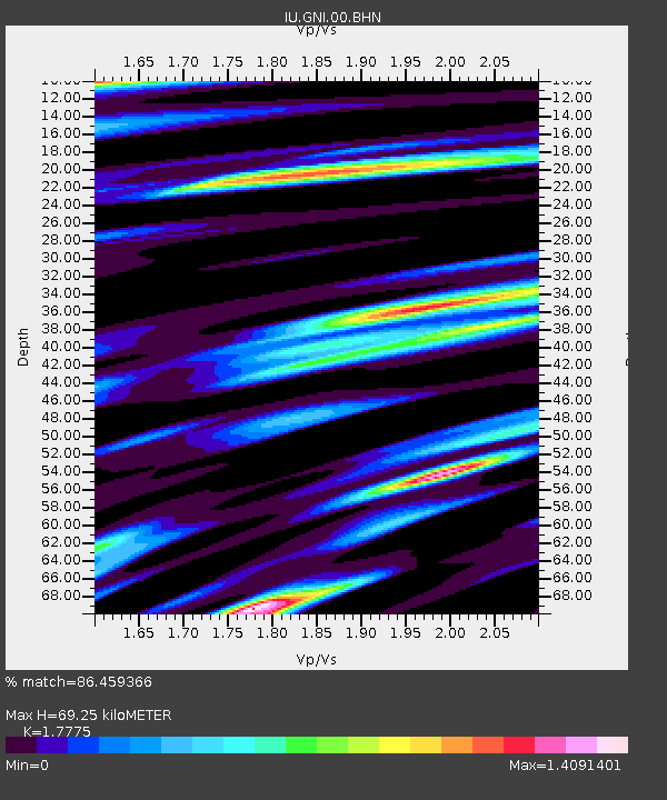
| Estimated Moho Depth: |
69.25 km |
| Estimated Crust Vp/Vs: |
1.78 |
| Assumed Crust Vp: |
6.291 km/s |
| Estimated Crust Vs: |
3.539 km/s |
| Estimated Crust Poisson's Ratio: |
0.27 |
|
| Radial Match: |
86.459366 % |
| Radial Bump: |
400 |
| Transverse Match: |
80.54288 % |
| Transverse Bump: |
400 |
| SOD ConfigId: |
20082 |
| Insert Time: |
2010-03-03 13:50:15.736 +0000 |
| GWidth: |
2.5 |
| Max Bumps: |
400 |
| Tol: |
0.001 |
|

Signal To Noise
| Channel | StoN | STA | LTA |
| IU:GNI:00:BHN:20010813T20:21:59.597021Z | 2.0631146 | 1.5519862E-7 | 7.5225394E-8 |
| IU:GNI:00:BHE:20010813T20:21:59.597021Z | 1.726571 | 1.6697611E-7 | 9.670968E-8 |
| IU:GNI:00:BHZ:20010813T20:21:59.597021Z | 31.067669 | 1.8741395E-6 | 6.032443E-8 |
| Arrivals |
| Ps | 8.9 SECOND |
| PpPs | 30 SECOND |
| PsPs/PpSs | 38 SECOND |


