You are here: Home > Network List > IU - Global Seismograph Network (GSN - IRIS/USGS) Stations List
> Station GNI Garni, Armenia > Earthquake Result Viewer
GNI Garni, Armenia - Earthquake Result Viewer
| Earthquake location: |
Western Honshu, Japan |
| Earthquake latitude/longitude: |
34.1/132.5 |
| Earthquake time(UTC): |
2001/03/24 (083) 06:27:53 GMT |
| Earthquake Depth: |
50 km |
| Earthquake Magnitude: |
6.4 MB, 6.5 MS, 6.8 MW, 6.4 ME |
| Earthquake Catalog/Contributor: |
WHDF/NEIC |
|
| Network: |
IU Global Seismograph Network (GSN - IRIS/USGS) |
| Station: |
GNI Garni, Armenia |
| Lat/Lon: |
40.15 N/44.74 E |
| Elevation: |
1609 m |
|
| Distance: |
67.5 deg |
| Az: |
303.994 deg |
| Baz: |
63.862 deg |
| Ray Param: |
0.05682034 |
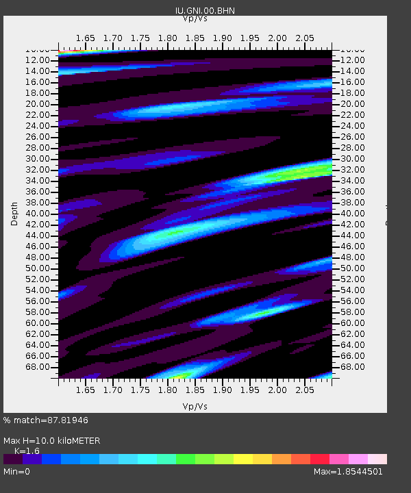
| Estimated Moho Depth: |
10.0 km |
| Estimated Crust Vp/Vs: |
1.60 |
| Assumed Crust Vp: |
6.291 km/s |
| Estimated Crust Vs: |
3.932 km/s |
| Estimated Crust Poisson's Ratio: |
0.18 |
|
| Radial Match: |
87.81946 % |
| Radial Bump: |
400 |
| Transverse Match: |
81.76318 % |
| Transverse Bump: |
400 |
| SOD ConfigId: |
4714 |
| Insert Time: |
2010-03-03 13:50:27.415 +0000 |
| GWidth: |
2.5 |
| Max Bumps: |
400 |
| Tol: |
0.001 |
|

Signal To Noise
| Channel | StoN | STA | LTA |
| IU:GNI:00:BHN:20010324T06:38:13.522017Z | 0.8346326 | 1.390236E-7 | 1.6656861E-7 |
| IU:GNI:00:BHE:20010324T06:38:13.522017Z | 0.9907892 | 1.7252555E-7 | 1.7412941E-7 |
| IU:GNI:00:BHZ:20010324T06:38:13.522017Z | 6.358174 | 8.4276667E-7 | 1.3254854E-7 |
| Arrivals |
| Ps | 1.0 SECOND |
| PpPs | 4.0 SECOND |
| PsPs/PpSs | 5.0 SECOND |


