You are here: Home > Network List > IU - Global Seismograph Network (GSN - IRIS/USGS) Stations List
> Station GNI Garni, Armenia > Earthquake Result Viewer
GNI Garni, Armenia - Earthquake Result Viewer
| Earthquake location: |
Mid-Indian Ridge |
| Earthquake latitude/longitude: |
-40.3/78.4 |
| Earthquake time(UTC): |
2001/01/15 (015) 05:52:16 GMT |
| Earthquake Depth: |
10 km |
| Earthquake Magnitude: |
5.7 MB, 6.3 MS, 6.4 MW, 6.3 MW |
| Earthquake Catalog/Contributor: |
WHDF/NEIC |
|
| Network: |
IU Global Seismograph Network (GSN - IRIS/USGS) |
| Station: |
GNI Garni, Armenia |
| Lat/Lon: |
40.15 N/44.74 E |
| Elevation: |
1609 m |
|
| Distance: |
85.8 deg |
| Az: |
334.813 deg |
| Baz: |
154.89 deg |
| Ray Param: |
0.04452414 |
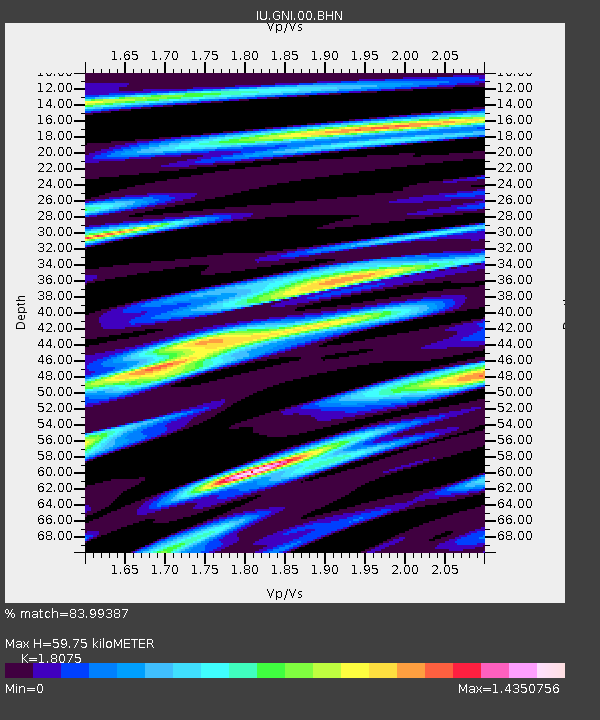
| Estimated Moho Depth: |
59.75 km |
| Estimated Crust Vp/Vs: |
1.81 |
| Assumed Crust Vp: |
6.291 km/s |
| Estimated Crust Vs: |
3.48 km/s |
| Estimated Crust Poisson's Ratio: |
0.28 |
|
| Radial Match: |
83.99387 % |
| Radial Bump: |
400 |
| Transverse Match: |
67.10031 % |
| Transverse Bump: |
400 |
| SOD ConfigId: |
3744 |
| Insert Time: |
2010-03-03 13:50:32.706 +0000 |
| GWidth: |
2.5 |
| Max Bumps: |
400 |
| Tol: |
0.001 |
|
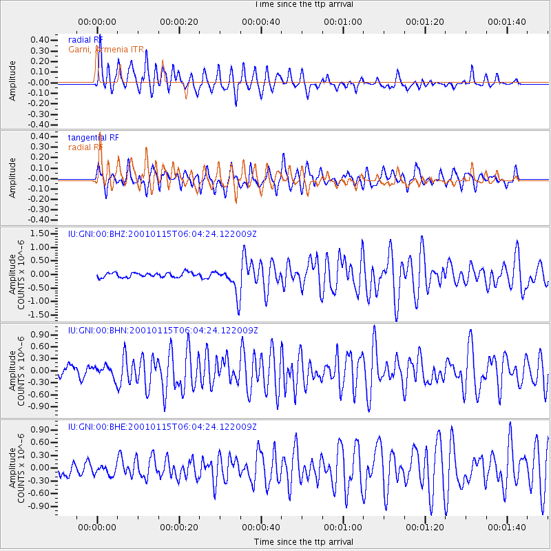
Signal To Noise
| Channel | StoN | STA | LTA |
| IU:GNI:00:BHN:20010115T06:04:24.122009Z | 1.080652 | 1.5636859E-7 | 1.4469836E-7 |
| IU:GNI:00:BHE:20010115T06:04:24.122009Z | 1.0011305 | 1.1902957E-7 | 1.1889517E-7 |
| IU:GNI:00:BHZ:20010115T06:04:24.122009Z | 6.328428 | 5.347458E-7 | 8.449901E-8 |
| Arrivals |
| Ps | 7.8 SECOND |
| PpPs | 26 SECOND |
| PsPs/PpSs | 34 SECOND |


