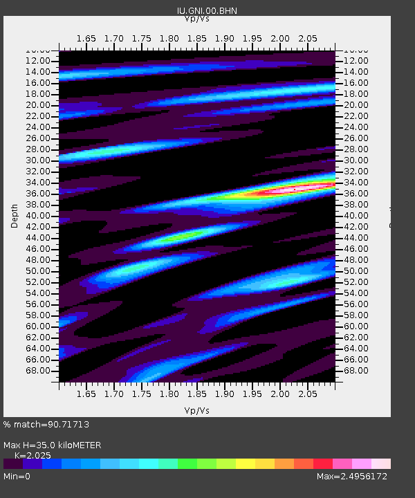
GNI Garni, Armenia - Earthquake Result Viewer
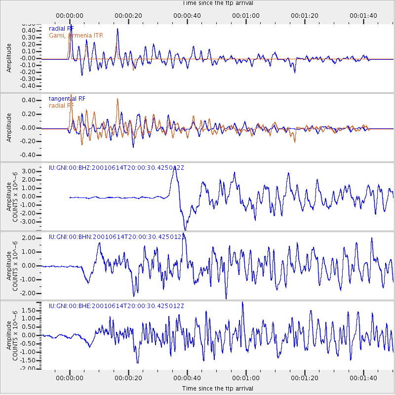
Earthquake location: Andreanof Islands, Aleutian Is.
Earthquake latitude/longitude: 51.2/-179.8
Earthquake time(UTC): 2001/06/14 (165) 19:48:47 GMT
Earthquake Depth: 18 km
Earthquake Magnitude: 6.0 MB, 6.3 MS, 6.5 MW, 6.1 ML
Earthquake Catalog/Contributor: WHDF/NEIC
Network: IU Global Seismograph Network (GSN - IRIS/USGS)
Station: GNI Garni, Armenia
Lat/Lon: 40.15 N/44.74 E
Elevation: 1609 m
Distance: 81.1 deg
Az: 327.01 deg
Baz: 26.571 deg
Ray Param: 0.047823343
Estimated Moho Depth: 35.0 km
Estimated Crust Vp/Vs: 2.03
Assumed Crust Vp: 6.291 km/s
Estimated Crust Vs: 3.107 km/s
Estimated Crust Poisson's Ratio: 0.34
Radial Match: 90.71713 %
Radial Bump: 400
Transverse Match: 84.21051 %
Transverse Bump: 400
SOD ConfigId: 4714
Insert Time: 2010-03-03 13:50:49.736 +0000
GWidth: 2.5
Max Bumps: 400
Tol: 0.001

Signal To Noise

ChannelStoNSTALTA
IU:GNI:00:BHN:20010614T20:00:30.425012Z2.40128951.3103204E-75.4567366E-8
IU:GNI:00:BHE:20010614T20:00:30.425012Z1.63144661.0382181E-76.363789E-8
IU:GNI:00:BHZ:20010614T20:00:30.425012Z13.7428026.547489E-74.764304E-8
Arrivals
Ps5.8 SECOND
PpPs16 SECOND
PsPs/PpSs22 SECOND