You are here: Home > Network List > IU - Global Seismograph Network (GSN - IRIS/USGS) Stations List
> Station GNI Garni, Armenia > Earthquake Result Viewer
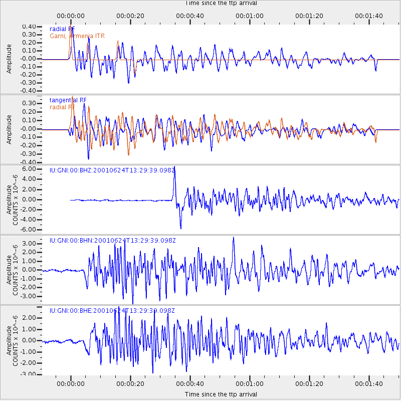
GNI Garni, Armenia - Earthquake Result Viewer

| Earthquake location: |
Kuril Islands |
| Earthquake latitude/longitude: |
44.2/148.5 |
| Earthquake time(UTC): |
2001/06/24 (175) 13:18:51 GMT |
| Earthquake Depth: |
33 km |
| Earthquake Magnitude: |
5.8 MB, 5.7 MS, 6.0 MW |
| Earthquake Catalog/Contributor: |
WHDF/NEIC |
|
| Network: |
IU Global Seismograph Network (GSN - IRIS/USGS) |
| Station: |
GNI Garni, Armenia |
| Lat/Lon: |
40.15 N/44.74 E |
| Elevation: |
1609 m |
|
| Distance: |
71.6 deg |
| Az: |
308.337 deg |
| Baz: |
47.405 deg |
| Ray Param: |
0.054138724 |
| Estimated Moho Depth: |
38.0 km |
| Estimated Crust Vp/Vs: |
1.99 |
| Assumed Crust Vp: |
6.291 km/s |
| Estimated Crust Vs: |
3.157 km/s |
| Estimated Crust Poisson's Ratio: |
0.33 |
|
| Radial Match: |
83.93026 % |
| Radial Bump: |
400 |
| Transverse Match: |
82.062546 % |
| Transverse Bump: |
400 |
| SOD ConfigId: |
4714 |
| Insert Time: |
2010-03-03 13:50:55.051 +0000 |
| GWidth: |
2.5 |
| Max Bumps: |
400 |
| Tol: |
0.001 |
|
Signal To Noise
| Channel | StoN | STA | LTA |
| IU:GNI:00:BHN:20010624T13:29:39.098Z | 2.79457 | 1.4614693E-7 | 5.2296752E-8 |
| IU:GNI:00:BHE:20010624T13:29:39.098Z | 1.4668044 | 1.5102577E-7 | 1.0296245E-7 |
| IU:GNI:00:BHZ:20010624T13:29:39.098Z | 20.280153 | 1.4387431E-6 | 7.094341E-8 |
| Arrivals |
| Ps | 6.2 SECOND |
| PpPs | 18 SECOND |
| PsPs/PpSs | 24 SECOND |


