You are here: Home > Network List > IU - Global Seismograph Network (GSN - IRIS/USGS) Stations List
> Station GNI Garni, Armenia > Earthquake Result Viewer
GNI Garni, Armenia - Earthquake Result Viewer
| Earthquake location: |
Mariana Islands |
| Earthquake latitude/longitude: |
18.9/146.8 |
| Earthquake time(UTC): |
2001/06/14 (165) 23:31:28 GMT |
| Earthquake Depth: |
33 km |
| Earthquake Magnitude: |
5.5 MB, 5.7 MS, 5.9 MW, 5.8 MW |
| Earthquake Catalog/Contributor: |
WHDF/NEIC |
|
| Network: |
IU Global Seismograph Network (GSN - IRIS/USGS) |
| Station: |
GNI Garni, Armenia |
| Lat/Lon: |
40.15 N/44.74 E |
| Elevation: |
1609 m |
|
| Distance: |
86.9 deg |
| Az: |
311.35 deg |
| Baz: |
68.043 deg |
| Ray Param: |
0.04368926 |
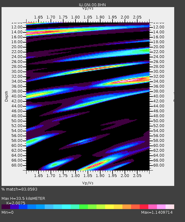
| Estimated Moho Depth: |
33.5 km |
| Estimated Crust Vp/Vs: |
2.01 |
| Assumed Crust Vp: |
6.291 km/s |
| Estimated Crust Vs: |
3.134 km/s |
| Estimated Crust Poisson's Ratio: |
0.33 |
|
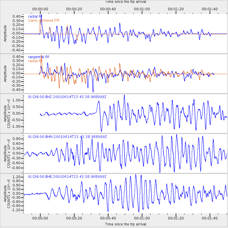
| Radial Match: |
83.8593 % |
| Radial Bump: |
400 |
| Transverse Match: |
70.243225 % |
| Transverse Bump: |
305 |
| SOD ConfigId: |
3753 |
| Insert Time: |
2010-03-03 13:51:03.937 +0000 |
| GWidth: |
2.5 |
| Max Bumps: |
400 |
| Tol: |
0.001 |
|
Signal To Noise
| Channel | StoN | STA | LTA |
| IU:GNI:00:BHN:20010614T23:43:38.968999Z | 0.8225893 | 5.967345E-8 | 7.254343E-8 |
| IU:GNI:00:BHE:20010614T23:43:38.968999Z | 1.4580764 | 9.9780394E-8 | 6.8432904E-8 |
| IU:GNI:00:BHZ:20010614T23:43:38.968999Z | 7.0495143 | 4.0933318E-7 | 5.8065446E-8 |
| Arrivals |
| Ps | 5.5 SECOND |
| PpPs | 16 SECOND |
| PsPs/PpSs | 21 SECOND |


