You are here: Home > Network List > TA - USArray Transportable Network (new EarthScope stations) Stations List
> Station H17A Grant Village (NPS), Yellowstone Nt. Park, WY, USA > Earthquake Result Viewer
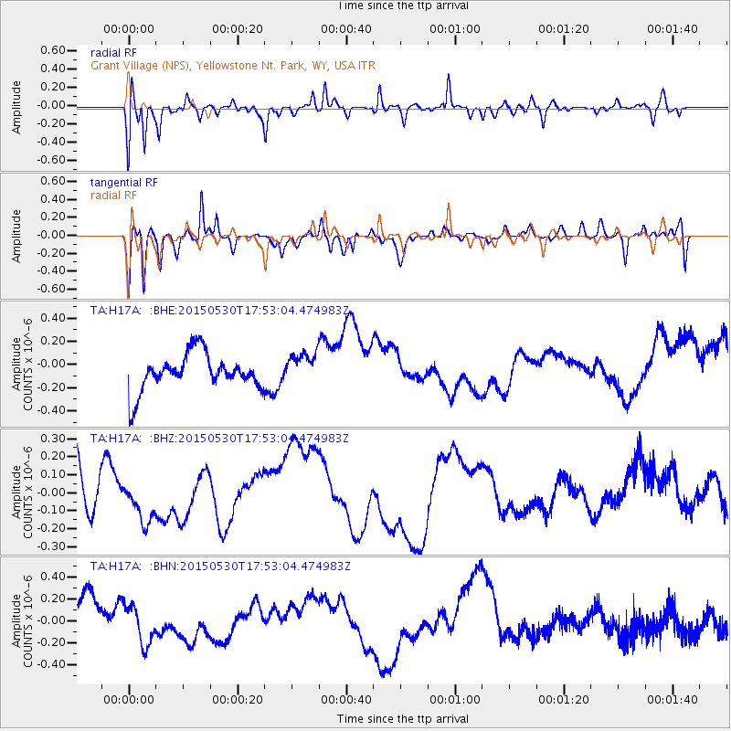
H17A Grant Village (NPS), Yellowstone Nt. Park, WY, USA - Earthquake Result Viewer
*The percent match for this event was below the threshold and hence no stack was calculated.
| Earthquake location: |
Solomon Islands |
| Earthquake latitude/longitude: |
-7.5/156.2 |
| Earthquake time(UTC): |
2015/05/30 (150) 17:40:06 GMT |
| Earthquake Depth: |
44 km |
| Earthquake Magnitude: |
4.7 mb, 4.7 mb |
| Earthquake Catalog/Contributor: |
ISC/ISC |
|
| Network: |
TA USArray Transportable Network (new EarthScope stations) |
| Station: |
H17A Grant Village (NPS), Yellowstone Nt. Park, WY, USA |
| Lat/Lon: |
44.40 N/110.58 W |
| Elevation: |
2400 m |
|
| Distance: |
97.4 deg |
| Az: |
46.207 deg |
| Baz: |
266.892 deg |
| Ray Param: |
$rayparam |
*The percent match for this event was below the threshold and hence was not used in the summary stack. |
|
| Radial Match: |
49.473286 % |
| Radial Bump: |
400 |
| Transverse Match: |
74.323875 % |
| Transverse Bump: |
400 |
| SOD ConfigId: |
7422571 |
| Insert Time: |
2019-04-19 03:38:22.943 +0000 |
| GWidth: |
2.5 |
| Max Bumps: |
400 |
| Tol: |
0.001 |
|
Signal To Noise
| Channel | StoN | STA | LTA |
| TA:H17A: :BHZ:20150530T17:53:04.474983Z | 0.9770942 | 1.18052306E-7 | 1.2081979E-7 |
| TA:H17A: :BHN:20150530T17:53:04.474983Z | 0.9574153 | 1.7243786E-7 | 1.801077E-7 |
| TA:H17A: :BHE:20150530T17:53:04.474983Z | 0.8747019 | 1.3777813E-7 | 1.5751436E-7 |
| Arrivals |
| Ps | |
| PpPs | |
| PsPs/PpSs | |


