You are here: Home > Network List > TA - USArray Transportable Network (new EarthScope stations) Stations List
> Station J01E Myrtle Point, OR, USA > Earthquake Result Viewer
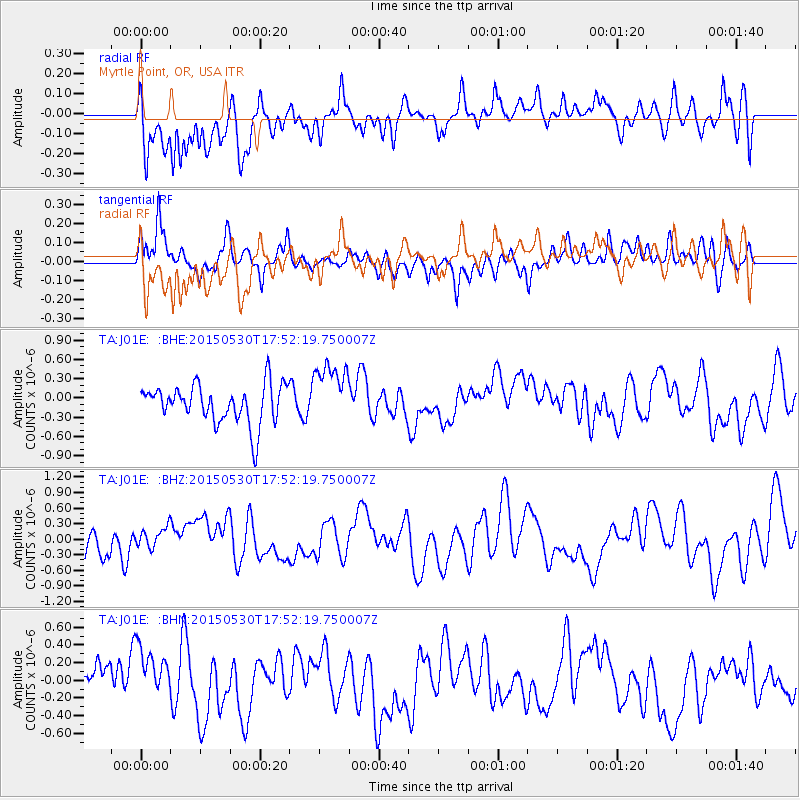
J01E Myrtle Point, OR, USA - Earthquake Result Viewer
*The percent match for this event was below the threshold and hence no stack was calculated.
| Earthquake location: |
Solomon Islands |
| Earthquake latitude/longitude: |
-7.5/156.2 |
| Earthquake time(UTC): |
2015/05/30 (150) 17:40:06 GMT |
| Earthquake Depth: |
44 km |
| Earthquake Magnitude: |
4.7 mb, 4.7 mb |
| Earthquake Catalog/Contributor: |
ISC/ISC |
|
| Network: |
TA USArray Transportable Network (new EarthScope stations) |
| Station: |
J01E Myrtle Point, OR, USA |
| Lat/Lon: |
43.16 N/123.93 W |
| Elevation: |
128 m |
|
| Distance: |
87.7 deg |
| Az: |
46.124 deg |
| Baz: |
257.666 deg |
| Ray Param: |
$rayparam |
*The percent match for this event was below the threshold and hence was not used in the summary stack. |
|
| Radial Match: |
73.41453 % |
| Radial Bump: |
400 |
| Transverse Match: |
49.499325 % |
| Transverse Bump: |
400 |
| SOD ConfigId: |
7422571 |
| Insert Time: |
2019-04-19 03:38:25.389 +0000 |
| GWidth: |
2.5 |
| Max Bumps: |
400 |
| Tol: |
0.001 |
|
Signal To Noise
| Channel | StoN | STA | LTA |
| TA:J01E: :BHZ:20150530T17:52:19.750007Z | 0.9091018 | 2.0575455E-7 | 2.263273E-7 |
| TA:J01E: :BHN:20150530T17:52:19.750007Z | 1.3190459 | 3.2959056E-7 | 2.4987042E-7 |
| TA:J01E: :BHE:20150530T17:52:19.750007Z | 1.6143657 | 4.8779503E-7 | 3.0215895E-7 |
| Arrivals |
| Ps | |
| PpPs | |
| PsPs/PpSs | |


