You are here: Home > Network List > IU - Global Seismograph Network (GSN - IRIS/USGS) Stations List
> Station GNI Garni, Armenia > Earthquake Result Viewer
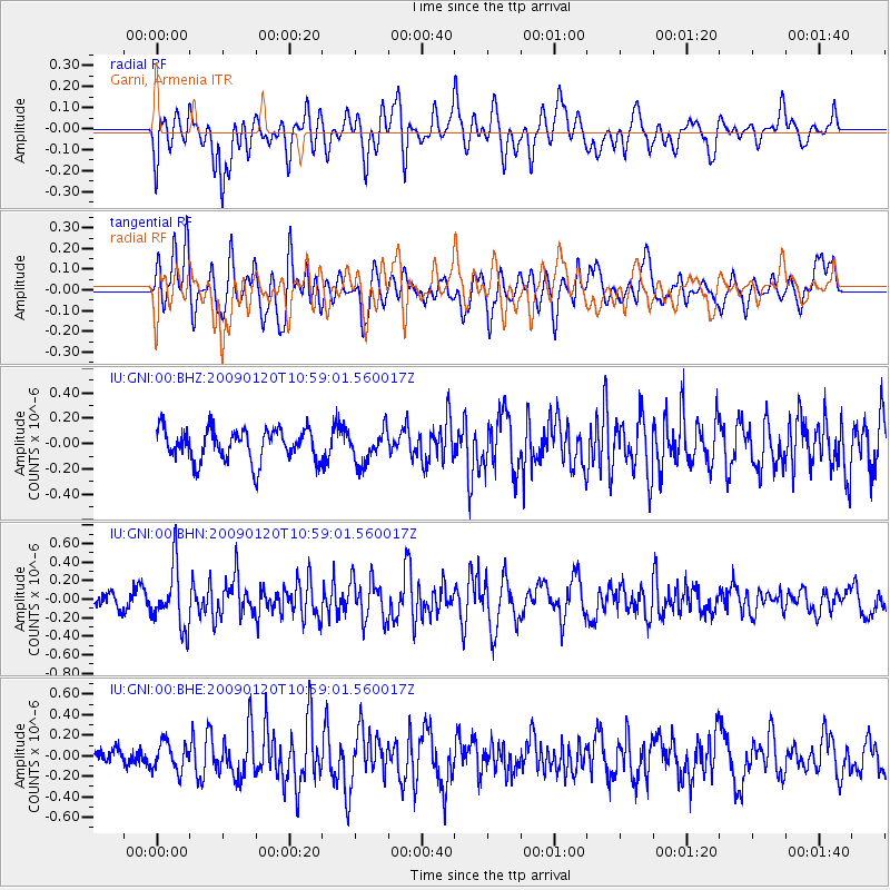
GNI Garni, Armenia - Earthquake Result Viewer
*The percent match for this event was below the threshold and hence no stack was calculated.
| Earthquake location: |
Banda Sea |
| Earthquake latitude/longitude: |
-4.7/129.8 |
| Earthquake time(UTC): |
2009/01/20 (020) 10:46:53 GMT |
| Earthquake Depth: |
144 km |
| Earthquake Magnitude: |
5.7 MB, 5.5 MW, 5.5 MW |
| Earthquake Catalog/Contributor: |
WHDF/NEIC |
|
| Network: |
IU Global Seismograph Network (GSN - IRIS/USGS) |
| Station: |
GNI Garni, Armenia |
| Lat/Lon: |
40.15 N/44.74 E |
| Elevation: |
1609 m |
|
| Distance: |
89.2 deg |
| Az: |
310.204 deg |
| Baz: |
96.716 deg |
| Ray Param: |
$rayparam |
*The percent match for this event was below the threshold and hence was not used in the summary stack. |
|
| Radial Match: |
58.604126 % |
| Radial Bump: |
400 |
| Transverse Match: |
49.984936 % |
| Transverse Bump: |
400 |
| SOD ConfigId: |
2834 |
| Insert Time: |
2010-03-03 13:52:02.658 +0000 |
| GWidth: |
2.5 |
| Max Bumps: |
400 |
| Tol: |
0.001 |
|
Signal To Noise
| Channel | StoN | STA | LTA |
| IU:GNI:00:BHN:20090120T10:59:01.560017Z | 3.0599267 | 3.2341134E-7 | 1.0569251E-7 |
| IU:GNI:00:BHE:20090120T10:59:01.560017Z | 1.0639158 | 1.3544845E-7 | 1.2731125E-7 |
| IU:GNI:00:BHZ:20090120T10:59:01.560017Z | 1.0349209 | 1.2868479E-7 | 1.2434262E-7 |
| Arrivals |
| Ps | |
| PpPs | |
| PsPs/PpSs | |


