You are here: Home > Network List > AK - Alaska Regional Network Stations List
> Station WRH Wood River Hill > Earthquake Result Viewer
WRH Wood River Hill - Earthquake Result Viewer
| Earthquake location: |
Southeast Of Honshu, Japan |
| Earthquake latitude/longitude: |
30.8/143.0 |
| Earthquake time(UTC): |
2015/05/30 (150) 18:49:07 GMT |
| Earthquake Depth: |
13 km |
| Earthquake Magnitude: |
6.4 MO |
| Earthquake Catalog/Contributor: |
NEIC PDE/NEIC ALERT |
|
| Network: |
AK Alaska Regional Network |
| Station: |
WRH Wood River Hill |
| Lat/Lon: |
64.47 N/148.09 W |
| Elevation: |
343 m |
|
| Distance: |
53.6 deg |
| Az: |
30.137 deg |
| Baz: |
265.81 deg |
| Ray Param: |
0.06596734 |
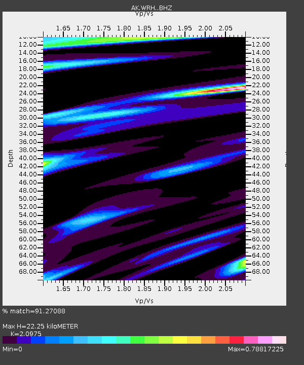
| Estimated Moho Depth: |
22.25 km |
| Estimated Crust Vp/Vs: |
2.10 |
| Assumed Crust Vp: |
6.566 km/s |
| Estimated Crust Vs: |
3.13 km/s |
| Estimated Crust Poisson's Ratio: |
0.35 |
|
| Radial Match: |
91.27088 % |
| Radial Bump: |
400 |
| Transverse Match: |
46.003563 % |
| Transverse Bump: |
400 |
| SOD ConfigId: |
7422571 |
| Insert Time: |
2019-04-19 03:41:57.944 +0000 |
| GWidth: |
2.5 |
| Max Bumps: |
400 |
| Tol: |
0.001 |
|

Signal To Noise
| Channel | StoN | STA | LTA |
| AK:WRH: :BHZ:20150530T18:57:57.828015Z | 9.69738 | 1.0751331E-6 | 1.1086841E-7 |
| AK:WRH: :BHN:20150530T18:57:57.828015Z | 1.5201057 | 2.4460567E-7 | 1.6091359E-7 |
| AK:WRH: :BHE:20150530T18:57:57.828015Z | 2.1323392 | 3.6760989E-7 | 1.7239748E-7 |
| Arrivals |
| Ps | 3.9 SECOND |
| PpPs | 10 SECOND |
| PsPs/PpSs | 14 SECOND |


