You are here: Home > Network List > IU - Global Seismograph Network (GSN - IRIS/USGS) Stations List
> Station GNI Garni, Armenia > Earthquake Result Viewer
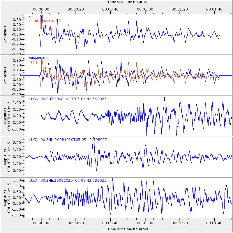
GNI Garni, Armenia - Earthquake Result Viewer
*The percent match for this event was below the threshold and hence no stack was calculated.
| Earthquake location: |
Minahassa Peninsula, Sulawesi |
| Earthquake latitude/longitude: |
0.1/120.7 |
| Earthquake time(UTC): |
2008/10/20 (294) 04:54:19 GMT |
| Earthquake Depth: |
102 km |
| Earthquake Magnitude: |
6.1 MB, 5.9 MW, 5.8 MW |
| Earthquake Catalog/Contributor: |
WHDF/NEIC |
|
| Network: |
IU Global Seismograph Network (GSN - IRIS/USGS) |
| Station: |
GNI Garni, Armenia |
| Lat/Lon: |
40.15 N/44.74 E |
| Elevation: |
1609 m |
|
| Distance: |
79.2 deg |
| Az: |
310.807 deg |
| Baz: |
99.074 deg |
| Ray Param: |
$rayparam |
*The percent match for this event was below the threshold and hence was not used in the summary stack. |
|
| Radial Match: |
65.71452 % |
| Radial Bump: |
400 |
| Transverse Match: |
77.83622 % |
| Transverse Bump: |
400 |
| SOD ConfigId: |
2556 |
| Insert Time: |
2010-03-03 13:53:20.968 +0000 |
| GWidth: |
2.5 |
| Max Bumps: |
400 |
| Tol: |
0.001 |
|
Signal To Noise
| Channel | StoN | STA | LTA |
| IU:GNI:00:BHN:20081020T05:05:42.59802Z | 3.2304907 | 2.6565112E-7 | 8.223244E-8 |
| IU:GNI:00:BHE:20081020T05:05:42.59802Z | 0.5633246 | 1.363686E-7 | 2.420782E-7 |
| IU:GNI:00:BHZ:20081020T05:05:42.59802Z | 0.6279212 | 1.5443213E-7 | 2.459419E-7 |
| Arrivals |
| Ps | |
| PpPs | |
| PsPs/PpSs | |


