You are here: Home > Network List > KR - Kyrgyz Digital Network Stations List
> Station BTK Batken, Kyrgyzstan > Earthquake Result Viewer
BTK Batken, Kyrgyzstan - Earthquake Result Viewer
| Earthquake location: |
Southeast Of Honshu, Japan |
| Earthquake latitude/longitude: |
30.8/143.0 |
| Earthquake time(UTC): |
2015/05/30 (150) 18:49:07 GMT |
| Earthquake Depth: |
13 km |
| Earthquake Magnitude: |
6.4 MO |
| Earthquake Catalog/Contributor: |
NEIC PDE/NEIC ALERT |
|
| Network: |
KR Kyrgyz Digital Network |
| Station: |
BTK Batken, Kyrgyzstan |
| Lat/Lon: |
40.06 N/70.82 E |
| Elevation: |
980 m |
|
| Distance: |
58.1 deg |
| Az: |
300.611 deg |
| Baz: |
74.843 deg |
| Ray Param: |
0.06304923 |
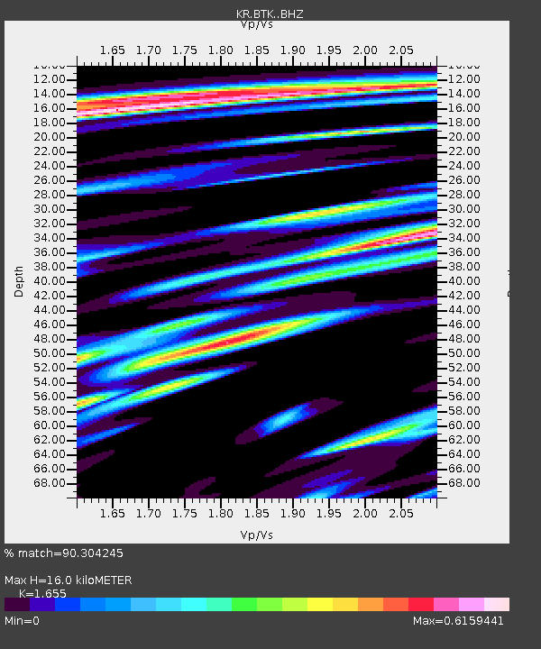
| Estimated Moho Depth: |
16.0 km |
| Estimated Crust Vp/Vs: |
1.65 |
| Assumed Crust Vp: |
6.236 km/s |
| Estimated Crust Vs: |
3.768 km/s |
| Estimated Crust Poisson's Ratio: |
0.21 |
|
| Radial Match: |
90.304245 % |
| Radial Bump: |
400 |
| Transverse Match: |
84.92018 % |
| Transverse Bump: |
400 |
| SOD ConfigId: |
7422571 |
| Insert Time: |
2019-04-19 03:46:12.569 +0000 |
| GWidth: |
2.5 |
| Max Bumps: |
400 |
| Tol: |
0.001 |
|

Signal To Noise
| Channel | StoN | STA | LTA |
| KR:BTK: :BHZ:20150530T18:58:29.675Z | 52.41679 | 2.2458564E-6 | 4.284613E-8 |
| KR:BTK: :BHN:20150530T18:58:29.675Z | 9.218346 | 4.3989505E-7 | 4.771952E-8 |
| KR:BTK: :BHE:20150530T18:58:29.675Z | 26.744669 | 8.994973E-7 | 3.363277E-8 |
| Arrivals |
| Ps | 1.8 SECOND |
| PpPs | 6.5 SECOND |
| PsPs/PpSs | 8.2 SECOND |


