You are here: Home > Network List > NN - Western Great Basin/Eastern Sierra Nevada Stations List
> Station GWY Greenwater Valley, CA. (GPS 12/06/2000) w84gm > Earthquake Result Viewer
GWY Greenwater Valley, CA. (GPS 12/06/2000) w84gm - Earthquake Result Viewer
| Earthquake location: |
Southeast Of Honshu, Japan |
| Earthquake latitude/longitude: |
30.8/143.0 |
| Earthquake time(UTC): |
2015/05/30 (150) 18:49:07 GMT |
| Earthquake Depth: |
13 km |
| Earthquake Magnitude: |
6.4 MO |
| Earthquake Catalog/Contributor: |
NEIC PDE/NEIC ALERT |
|
| Network: |
NN Western Great Basin/Eastern Sierra Nevada |
| Station: |
GWY Greenwater Valley, CA. (GPS 12/06/2000) w84gm |
| Lat/Lon: |
36.19 N/116.67 W |
| Elevation: |
1538 m |
|
| Distance: |
79.9 deg |
| Az: |
53.934 deg |
| Baz: |
300.676 deg |
| Ray Param: |
0.048607767 |
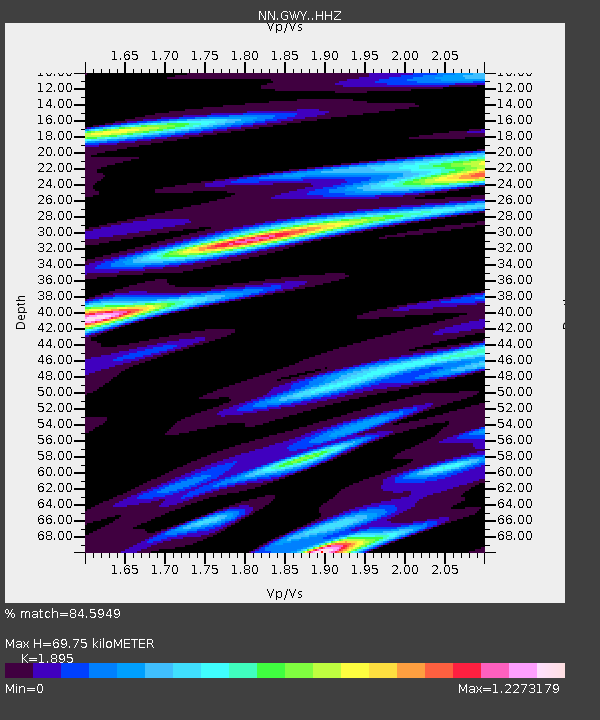
| Estimated Moho Depth: |
69.75 km |
| Estimated Crust Vp/Vs: |
1.89 |
| Assumed Crust Vp: |
6.279 km/s |
| Estimated Crust Vs: |
3.313 km/s |
| Estimated Crust Poisson's Ratio: |
0.31 |
|
| Radial Match: |
84.5949 % |
| Radial Bump: |
400 |
| Transverse Match: |
66.14301 % |
| Transverse Bump: |
400 |
| SOD ConfigId: |
7422571 |
| Insert Time: |
2019-04-19 03:47:35.881 +0000 |
| GWidth: |
2.5 |
| Max Bumps: |
400 |
| Tol: |
0.001 |
|

Signal To Noise
| Channel | StoN | STA | LTA |
| NN:GWY: :HHZ:20150530T19:00:45.278027Z | 3.2736385 | 6.6436047E-7 | 2.0294253E-7 |
| NN:GWY: :HHN:20150530T19:00:45.278027Z | 1.5243787 | 2.41199E-7 | 1.5822775E-7 |
| NN:GWY: :HHE:20150530T19:00:45.278027Z | 1.5545886 | 2.5395676E-7 | 1.6335947E-7 |
| Arrivals |
| Ps | 10 SECOND |
| PpPs | 31 SECOND |
| PsPs/PpSs | 42 SECOND |


