You are here: Home > Network List > TA - USArray Transportable Network (new EarthScope stations) Stations List
> Station A04D Lummi Island, WA, USA > Earthquake Result Viewer
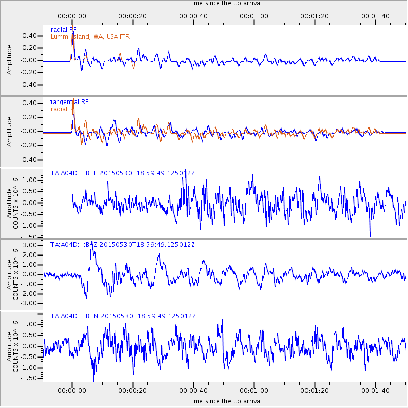
A04D Lummi Island, WA, USA - Earthquake Result Viewer
*The percent match for this event was below the threshold and hence no stack was calculated.
| Earthquake location: |
Southeast Of Honshu, Japan |
| Earthquake latitude/longitude: |
30.8/143.0 |
| Earthquake time(UTC): |
2015/05/30 (150) 18:49:07 GMT |
| Earthquake Depth: |
13 km |
| Earthquake Magnitude: |
6.4 MO |
| Earthquake Catalog/Contributor: |
NEIC PDE/NEIC ALERT |
|
| Network: |
TA USArray Transportable Network (new EarthScope stations) |
| Station: |
A04D Lummi Island, WA, USA |
| Lat/Lon: |
48.72 N/122.71 W |
| Elevation: |
13 m |
|
| Distance: |
70.2 deg |
| Az: |
44.583 deg |
| Baz: |
294.166 deg |
| Ray Param: |
$rayparam |
*The percent match for this event was below the threshold and hence was not used in the summary stack. |
|
| Radial Match: |
84.8916 % |
| Radial Bump: |
400 |
| Transverse Match: |
76.699425 % |
| Transverse Bump: |
400 |
| SOD ConfigId: |
7422571 |
| Insert Time: |
2019-04-19 03:49:13.843 +0000 |
| GWidth: |
2.5 |
| Max Bumps: |
400 |
| Tol: |
0.001 |
|
Signal To Noise
| Channel | StoN | STA | LTA |
| TA:A04D: :BHZ:20150530T18:59:49.125012Z | 5.364001 | 8.7055844E-7 | 1.6229649E-7 |
| TA:A04D: :BHN:20150530T18:59:49.125012Z | 1.6505958 | 3.5090895E-7 | 2.1259532E-7 |
| TA:A04D: :BHE:20150530T18:59:49.125012Z | 1.5200821 | 3.6829368E-7 | 2.4228538E-7 |
| Arrivals |
| Ps | |
| PpPs | |
| PsPs/PpSs | |


