You are here: Home > Network List > TA - USArray Transportable Network (new EarthScope stations) Stations List
> Station A21K Barrow, AK, USA > Earthquake Result Viewer
A21K Barrow, AK, USA - Earthquake Result Viewer
| Earthquake location: |
Southeast Of Honshu, Japan |
| Earthquake latitude/longitude: |
30.8/143.0 |
| Earthquake time(UTC): |
2015/05/30 (150) 18:49:07 GMT |
| Earthquake Depth: |
13 km |
| Earthquake Magnitude: |
6.4 MO |
| Earthquake Catalog/Contributor: |
NEIC PDE/NEIC ALERT |
|
| Network: |
TA USArray Transportable Network (new EarthScope stations) |
| Station: |
A21K Barrow, AK, USA |
| Lat/Lon: |
71.32 N/156.62 W |
| Elevation: |
577 m |
|
| Distance: |
51.8 deg |
| Az: |
20.889 deg |
| Baz: |
252.286 deg |
| Ray Param: |
0.067197464 |
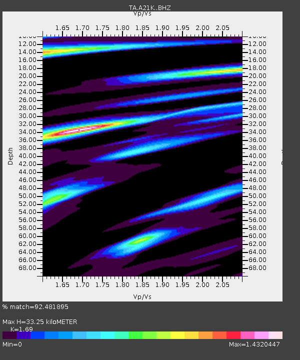
| Estimated Moho Depth: |
33.25 km |
| Estimated Crust Vp/Vs: |
1.69 |
| Assumed Crust Vp: |
6.048 km/s |
| Estimated Crust Vs: |
3.579 km/s |
| Estimated Crust Poisson's Ratio: |
0.23 |
|
| Radial Match: |
92.481895 % |
| Radial Bump: |
400 |
| Transverse Match: |
81.74149 % |
| Transverse Bump: |
400 |
| SOD ConfigId: |
7422571 |
| Insert Time: |
2019-04-19 03:49:14.828 +0000 |
| GWidth: |
2.5 |
| Max Bumps: |
400 |
| Tol: |
0.001 |
|

Signal To Noise
| Channel | StoN | STA | LTA |
| TA:A21K: :BHZ:20150530T18:57:43.974988Z | 18.724506 | 1.3343516E-6 | 7.126231E-8 |
| TA:A21K: :BHN:20150530T18:57:43.974988Z | 4.0036755 | 4.1956895E-7 | 1.0479594E-7 |
| TA:A21K: :BHE:20150530T18:57:43.974988Z | 8.5799055 | 6.281469E-7 | 7.3211396E-8 |
| Arrivals |
| Ps | 4.0 SECOND |
| PpPs | 14 SECOND |
| PsPs/PpSs | 18 SECOND |


