You are here: Home > Network List > IU - Global Seismograph Network (GSN - IRIS/USGS) Stations List
> Station GNI Garni, Armenia > Earthquake Result Viewer
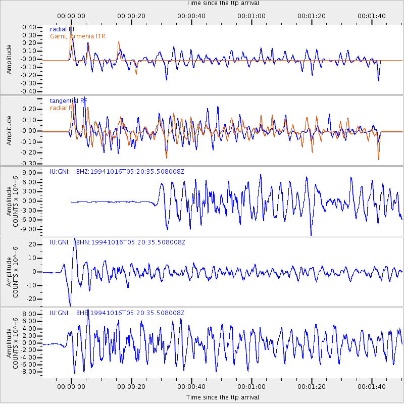
GNI Garni, Armenia - Earthquake Result Viewer
*The percent match for this event was below the threshold and hence no stack was calculated.
| Earthquake location: |
Kuril Islands |
| Earthquake latitude/longitude: |
45.7/149.2 |
| Earthquake time(UTC): |
1994/10/16 (289) 05:10:03 GMT |
| Earthquake Depth: |
139 km |
| Earthquake Magnitude: |
6.3 MB, 6.8 UNKNOWN, 6.7 MW |
| Earthquake Catalog/Contributor: |
WHDF/NEIC |
|
| Network: |
IU Global Seismograph Network (GSN - IRIS/USGS) |
| Station: |
GNI Garni, Armenia |
| Lat/Lon: |
40.15 N/44.74 E |
| Elevation: |
1609 m |
|
| Distance: |
71.1 deg |
| Az: |
308.322 deg |
| Baz: |
45.79 deg |
| Ray Param: |
$rayparam |
*The percent match for this event was below the threshold and hence was not used in the summary stack. |
|
| Radial Match: |
79.71464 % |
| Radial Bump: |
400 |
| Transverse Match: |
80.93737 % |
| Transverse Bump: |
400 |
| SOD ConfigId: |
4480 |
| Insert Time: |
2010-03-03 13:54:43.444 +0000 |
| GWidth: |
2.5 |
| Max Bumps: |
400 |
| Tol: |
0.001 |
|
Signal To Noise
| Channel | StoN | STA | LTA |
| IU:GNI: :BHN:19941016T05:20:35.508008Z | 149.9085 | 1.3646612E-5 | 9.103295E-8 |
| IU:GNI: :BHE:19941016T05:20:35.508008Z | 33.585148 | 4.1224375E-6 | 1.2274585E-7 |
| IU:GNI: :BHZ:19941016T05:20:35.508008Z | 74.95118 | 4.9210953E-6 | 6.565734E-8 |
| Arrivals |
| Ps | |
| PpPs | |
| PsPs/PpSs | |


