You are here: Home > Network List > IU - Global Seismograph Network (GSN - IRIS/USGS) Stations List
> Station GNI Garni, Armenia > Earthquake Result Viewer
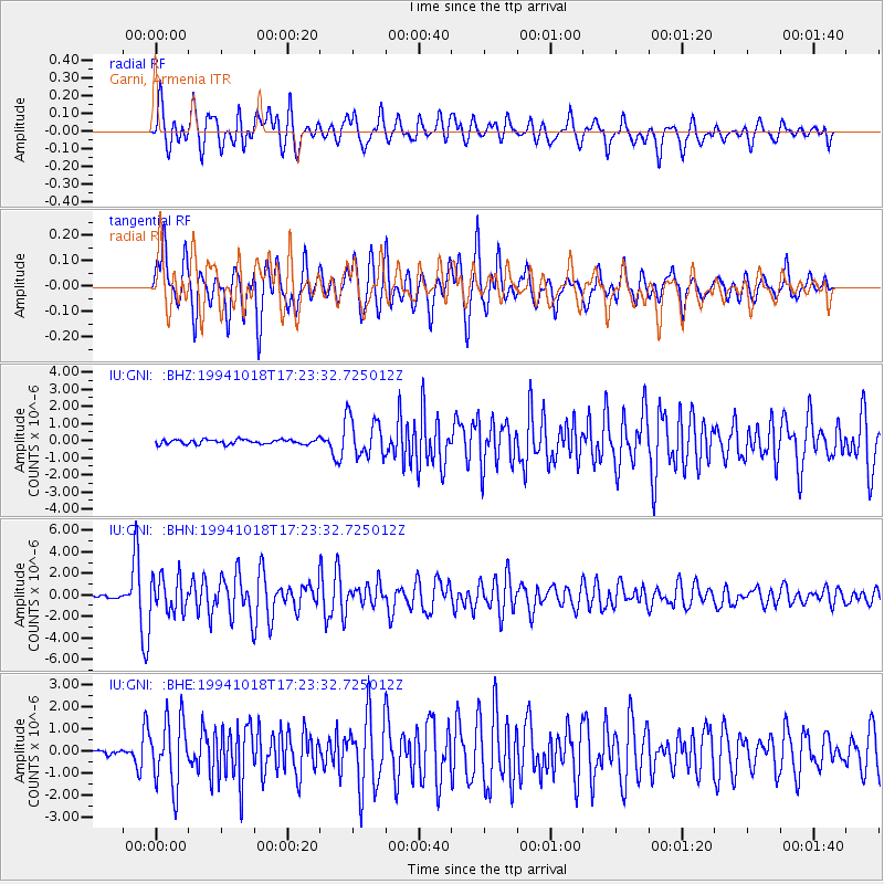
GNI Garni, Armenia - Earthquake Result Viewer
*The percent match for this event was below the threshold and hence no stack was calculated.
| Earthquake location: |
Kuril Islands |
| Earthquake latitude/longitude: |
43.6/147.1 |
| Earthquake time(UTC): |
1994/10/18 (291) 17:12:51 GMT |
| Earthquake Depth: |
66 km |
| Earthquake Magnitude: |
6.1 MB, 6.1 UNKNOWN, 5.9 MW |
| Earthquake Catalog/Contributor: |
WHDF/NEIC |
|
| Network: |
IU Global Seismograph Network (GSN - IRIS/USGS) |
| Station: |
GNI Garni, Armenia |
| Lat/Lon: |
40.15 N/44.74 E |
| Elevation: |
1609 m |
|
| Distance: |
71.2 deg |
| Az: |
307.755 deg |
| Baz: |
48.584 deg |
| Ray Param: |
$rayparam |
*The percent match for this event was below the threshold and hence was not used in the summary stack. |
|
| Radial Match: |
78.80749 % |
| Radial Bump: |
400 |
| Transverse Match: |
84.79034 % |
| Transverse Bump: |
400 |
| SOD ConfigId: |
4480 |
| Insert Time: |
2010-03-03 13:54:46.201 +0000 |
| GWidth: |
2.5 |
| Max Bumps: |
400 |
| Tol: |
0.001 |
|
Signal To Noise
| Channel | StoN | STA | LTA |
| IU:GNI: :BHN:19941018T17:23:32.725012Z | 18.81007 | 1.6912011E-6 | 8.990934E-8 |
| IU:GNI: :BHE:19941018T17:23:32.725012Z | 15.184712 | 1.4775159E-6 | 9.730285E-8 |
| IU:GNI: :BHZ:19941018T17:23:32.725012Z | 8.704478 | 1.1483007E-6 | 1.3192067E-7 |
| Arrivals |
| Ps | |
| PpPs | |
| PsPs/PpSs | |


