You are here: Home > Network List > TA - USArray Transportable Network (new EarthScope stations) Stations List
> Station TPFO Pinon Flats, CA, USA > Earthquake Result Viewer
TPFO Pinon Flats, CA, USA - Earthquake Result Viewer
| Earthquake location: |
Southeast Of Honshu, Japan |
| Earthquake latitude/longitude: |
30.8/143.0 |
| Earthquake time(UTC): |
2015/05/30 (150) 18:49:07 GMT |
| Earthquake Depth: |
13 km |
| Earthquake Magnitude: |
6.4 MO |
| Earthquake Catalog/Contributor: |
NEIC PDE/NEIC ALERT |
|
| Network: |
TA USArray Transportable Network (new EarthScope stations) |
| Station: |
TPFO Pinon Flats, CA, USA |
| Lat/Lon: |
33.61 N/116.45 W |
| Elevation: |
1275 m |
|
| Distance: |
81.4 deg |
| Az: |
56.08 deg |
| Baz: |
301.147 deg |
| Ray Param: |
0.04759393 |
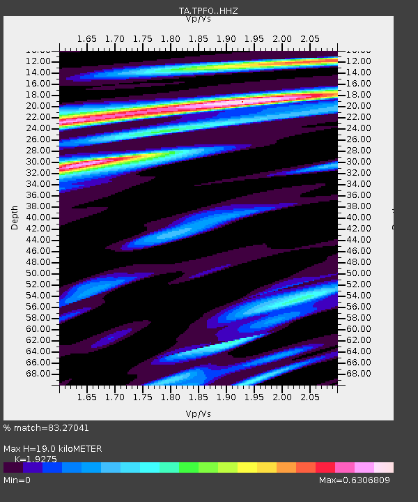
| Estimated Moho Depth: |
19.0 km |
| Estimated Crust Vp/Vs: |
1.93 |
| Assumed Crust Vp: |
6.264 km/s |
| Estimated Crust Vs: |
3.25 km/s |
| Estimated Crust Poisson's Ratio: |
0.32 |
|
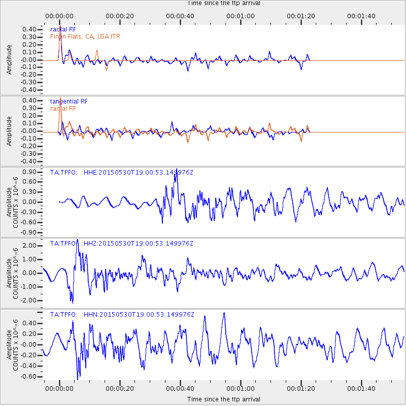
| Radial Match: |
83.27041 % |
| Radial Bump: |
400 |
| Transverse Match: |
65.43399 % |
| Transverse Bump: |
375 |
| SOD ConfigId: |
7422571 |
| Insert Time: |
2019-04-19 03:50:08.447 +0000 |
| GWidth: |
2.5 |
| Max Bumps: |
400 |
| Tol: |
0.001 |
|
Signal To Noise
| Channel | StoN | STA | LTA |
| TA:TPFO: :HHZ:20150530T19:00:53.149976Z | 3.9897256 | 8.8254654E-7 | 2.2120481E-7 |
| TA:TPFO: :HHN:20150530T19:00:53.149976Z | 1.0180961 | 1.8818105E-7 | 1.8483622E-7 |
| TA:TPFO: :HHE:20150530T19:00:53.149976Z | 1.9179193 | 1.777765E-7 | 9.269238E-8 |
| Arrivals |
| Ps | 2.9 SECOND |
| PpPs | 8.7 SECOND |
| PsPs/PpSs | 12 SECOND |


