You are here: Home > Network List > TA - USArray Transportable Network (new EarthScope stations) Stations List
> Station I23K Minto, Yukon-Koyukuk, AK, USA > Earthquake Result Viewer
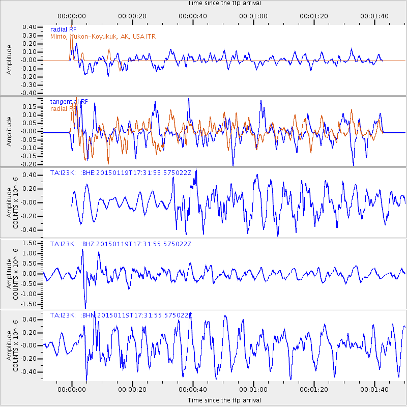
I23K Minto, Yukon-Koyukuk, AK, USA - Earthquake Result Viewer
*The percent match for this event was below the threshold and hence no stack was calculated.
| Earthquake location: |
Sulu Archipelago, Philippines |
| Earthquake latitude/longitude: |
4.6/119.8 |
| Earthquake time(UTC): |
2015/01/19 (019) 17:19:45 GMT |
| Earthquake Depth: |
11 km |
| Earthquake Magnitude: |
5.5 MWB |
| Earthquake Catalog/Contributor: |
NEIC PDE/NEIC COMCAT |
|
| Network: |
TA USArray Transportable Network (new EarthScope stations) |
| Station: |
I23K Minto, Yukon-Koyukuk, AK, USA |
| Lat/Lon: |
65.15 N/149.36 W |
| Elevation: |
149 m |
|
| Distance: |
86.2 deg |
| Az: |
25.055 deg |
| Baz: |
272.74 deg |
| Ray Param: |
$rayparam |
*The percent match for this event was below the threshold and hence was not used in the summary stack. |
|
| Radial Match: |
51.809517 % |
| Radial Bump: |
400 |
| Transverse Match: |
52.543415 % |
| Transverse Bump: |
397 |
| SOD ConfigId: |
837871 |
| Insert Time: |
2015-02-02 17:38:00.866 +0000 |
| GWidth: |
2.5 |
| Max Bumps: |
400 |
| Tol: |
0.001 |
|
Signal To Noise
| Channel | StoN | STA | LTA |
| TA:I23K: :BHZ:20150119T17:31:55.575022Z | 4.175515 | 6.032265E-7 | 1.4446756E-7 |
| TA:I23K: :BHN:20150119T17:31:55.575022Z | 1.2795017 | 1.6501811E-7 | 1.289706E-7 |
| TA:I23K: :BHE:20150119T17:31:55.575022Z | 1.2094889 | 1.5014461E-7 | 1.241389E-7 |
| Arrivals |
| Ps | |
| PpPs | |
| PsPs/PpSs | |


