You are here: Home > Network List > IU - Global Seismograph Network (GSN - IRIS/USGS) Stations List
> Station GNI Garni, Armenia > Earthquake Result Viewer
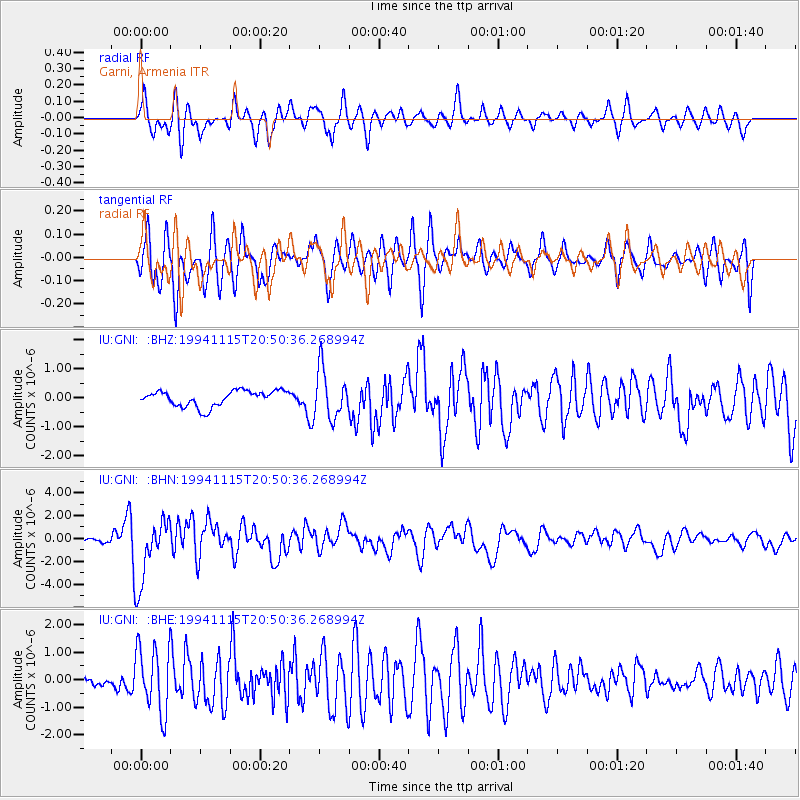
GNI Garni, Armenia - Earthquake Result Viewer
*The percent match for this event was below the threshold and hence no stack was calculated.
| Earthquake location: |
East Of Kuril Islands |
| Earthquake latitude/longitude: |
47.5/155.1 |
| Earthquake time(UTC): |
1994/11/15 (319) 20:39:40 GMT |
| Earthquake Depth: |
33 km |
| Earthquake Magnitude: |
5.7 MB, 6.0 MS, 5.6 UNKNOWN, 6.0 MW |
| Earthquake Catalog/Contributor: |
WHDF/NEIC |
|
| Network: |
IU Global Seismograph Network (GSN - IRIS/USGS) |
| Station: |
GNI Garni, Armenia |
| Lat/Lon: |
40.15 N/44.74 E |
| Elevation: |
1609 m |
|
| Distance: |
73.1 deg |
| Az: |
311.314 deg |
| Baz: |
41.678 deg |
| Ray Param: |
$rayparam |
*The percent match for this event was below the threshold and hence was not used in the summary stack. |
|
| Radial Match: |
79.6472 % |
| Radial Bump: |
400 |
| Transverse Match: |
79.56162 % |
| Transverse Bump: |
400 |
| SOD ConfigId: |
4480 |
| Insert Time: |
2010-03-03 13:55:08.921 +0000 |
| GWidth: |
2.5 |
| Max Bumps: |
400 |
| Tol: |
0.001 |
|
Signal To Noise
| Channel | StoN | STA | LTA |
| IU:GNI: :BHN:19941115T20:50:36.268994Z | 15.30374 | 2.861293E-6 | 1.8696691E-7 |
| IU:GNI: :BHE:19941115T20:50:36.268994Z | 11.999507 | 1.1945006E-6 | 9.95458E-8 |
| IU:GNI: :BHZ:19941115T20:50:36.268994Z | 3.1105926 | 8.383825E-7 | 2.6952503E-7 |
| Arrivals |
| Ps | |
| PpPs | |
| PsPs/PpSs | |


