You are here: Home > Network List > TJ - Tajikistan National Seismic Network Stations List
> Station CHGR Chuyangaron, Tajikistan > Earthquake Result Viewer
CHGR Chuyangaron, Tajikistan - Earthquake Result Viewer
| Earthquake location: |
Southeast Of Honshu, Japan |
| Earthquake latitude/longitude: |
30.8/143.0 |
| Earthquake time(UTC): |
2015/05/30 (150) 18:49:07 GMT |
| Earthquake Depth: |
13 km |
| Earthquake Magnitude: |
6.4 MO |
| Earthquake Catalog/Contributor: |
NEIC PDE/NEIC ALERT |
|
| Network: |
TJ Tajikistan National Seismic Network |
| Station: |
CHGR Chuyangaron, Tajikistan |
| Lat/Lon: |
38.66 N/69.16 E |
| Elevation: |
1049 m |
|
| Distance: |
59.7 deg |
| Az: |
299.453 deg |
| Baz: |
73.195 deg |
| Ray Param: |
0.061984535 |
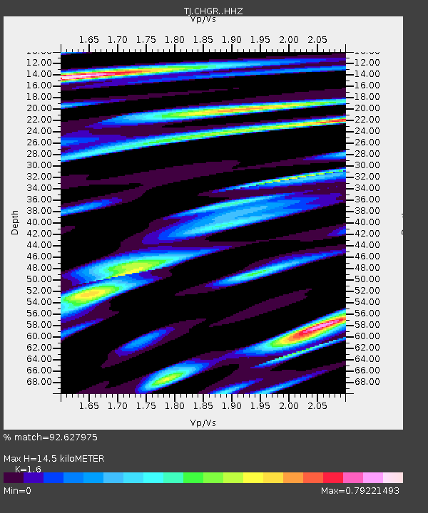
| Estimated Moho Depth: |
14.5 km |
| Estimated Crust Vp/Vs: |
1.60 |
| Assumed Crust Vp: |
6.483 km/s |
| Estimated Crust Vs: |
4.052 km/s |
| Estimated Crust Poisson's Ratio: |
0.18 |
|
| Radial Match: |
92.627975 % |
| Radial Bump: |
400 |
| Transverse Match: |
84.096825 % |
| Transverse Bump: |
400 |
| SOD ConfigId: |
7422571 |
| Insert Time: |
2019-04-19 03:50:21.994 +0000 |
| GWidth: |
2.5 |
| Max Bumps: |
400 |
| Tol: |
0.001 |
|

Signal To Noise
| Channel | StoN | STA | LTA |
| TJ:CHGR: :HHZ:20150530T18:58:40.919995Z | 68.03369 | 7.5718685E-6 | 1.1129587E-7 |
| TJ:CHGR: :HHN:20150530T18:58:40.919995Z | 13.220321 | 8.751706E-7 | 6.619889E-8 |
| TJ:CHGR: :HHE:20150530T18:58:40.919995Z | 39.05491 | 2.859997E-6 | 7.3230154E-8 |
| Arrivals |
| Ps | 1.4 SECOND |
| PpPs | 5.5 SECOND |
| PsPs/PpSs | 6.9 SECOND |


