You are here: Home > Network List > IU - Global Seismograph Network (GSN - IRIS/USGS) Stations List
> Station GNI Garni, Armenia > Earthquake Result Viewer
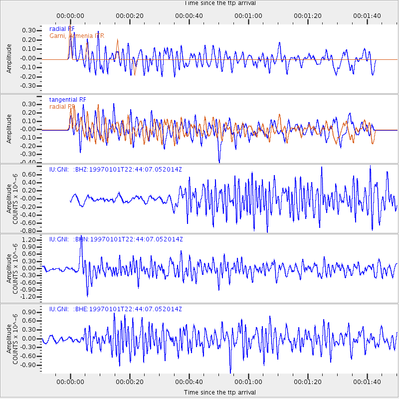
GNI Garni, Armenia - Earthquake Result Viewer
*The percent match for this event was below the threshold and hence no stack was calculated.
| Earthquake location: |
Minahassa Peninsula, Sulawesi |
| Earthquake latitude/longitude: |
-0.1/123.8 |
| Earthquake time(UTC): |
1997/01/01 (001) 22:32:32 GMT |
| Earthquake Depth: |
115 km |
| Earthquake Magnitude: |
5.9 MB, 5.8 UNKNOWN, 5.7 MW |
| Earthquake Catalog/Contributor: |
WHDF/NEIC |
|
| Network: |
IU Global Seismograph Network (GSN - IRIS/USGS) |
| Station: |
GNI Garni, Armenia |
| Lat/Lon: |
40.15 N/44.74 E |
| Elevation: |
1609 m |
|
| Distance: |
81.7 deg |
| Az: |
310.488 deg |
| Baz: |
97.159 deg |
| Ray Param: |
$rayparam |
*The percent match for this event was below the threshold and hence was not used in the summary stack. |
|
| Radial Match: |
60.44175 % |
| Radial Bump: |
400 |
| Transverse Match: |
63.529224 % |
| Transverse Bump: |
400 |
| SOD ConfigId: |
4480 |
| Insert Time: |
2010-03-03 13:55:27.047 +0000 |
| GWidth: |
2.5 |
| Max Bumps: |
400 |
| Tol: |
0.001 |
|
Signal To Noise
| Channel | StoN | STA | LTA |
| IU:GNI: :BHN:19970101T22:44:07.052014Z | 6.373838 | 4.3908256E-7 | 6.8888255E-8 |
| IU:GNI: :BHE:19970101T22:44:07.052014Z | 0.7349768 | 8.0273175E-8 | 1.0921865E-7 |
| IU:GNI: :BHZ:19970101T22:44:07.052014Z | 1.468728 | 9.841915E-8 | 6.700979E-8 |
| Arrivals |
| Ps | |
| PpPs | |
| PsPs/PpSs | |


