You are here: Home > Network List > UW - Pacific Northwest Regional Seismic Network Stations List
> Station LEBA Lebam, WA, USA > Earthquake Result Viewer
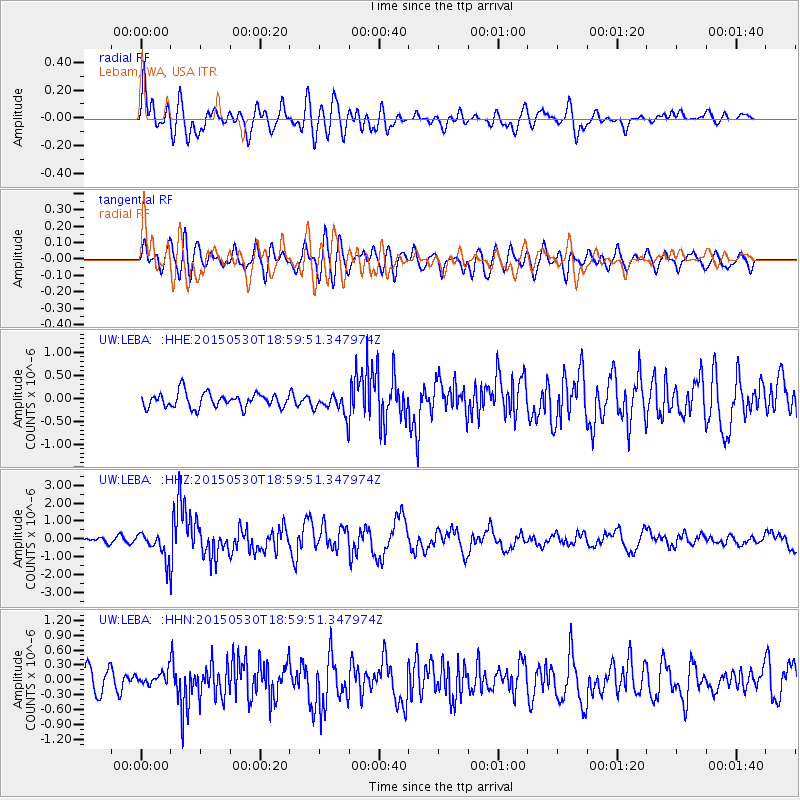
LEBA Lebam, WA, USA - Earthquake Result Viewer
*The percent match for this event was below the threshold and hence no stack was calculated.
| Earthquake location: |
Southeast Of Honshu, Japan |
| Earthquake latitude/longitude: |
30.8/143.0 |
| Earthquake time(UTC): |
2015/05/30 (150) 18:49:07 GMT |
| Earthquake Depth: |
13 km |
| Earthquake Magnitude: |
6.4 MO |
| Earthquake Catalog/Contributor: |
NEIC PDE/NEIC ALERT |
|
| Network: |
UW Pacific Northwest Regional Seismic Network |
| Station: |
LEBA Lebam, WA, USA |
| Lat/Lon: |
46.55 N/123.56 W |
| Elevation: |
73 m |
|
| Distance: |
70.6 deg |
| Az: |
46.942 deg |
| Baz: |
294.328 deg |
| Ray Param: |
$rayparam |
*The percent match for this event was below the threshold and hence was not used in the summary stack. |
|
| Radial Match: |
76.09783 % |
| Radial Bump: |
400 |
| Transverse Match: |
70.455986 % |
| Transverse Bump: |
400 |
| SOD ConfigId: |
7422571 |
| Insert Time: |
2019-04-19 03:51:17.064 +0000 |
| GWidth: |
2.5 |
| Max Bumps: |
400 |
| Tol: |
0.001 |
|
Signal To Noise
| Channel | StoN | STA | LTA |
| UW:LEBA: :HHZ:20150530T18:59:51.347974Z | 4.7219796 | 7.5201683E-7 | 1.592588E-7 |
| UW:LEBA: :HHN:20150530T18:59:51.347974Z | 0.5556898 | 1.3044595E-7 | 2.34746E-7 |
| UW:LEBA: :HHE:20150530T18:59:51.347974Z | 1.0990683 | 1.7487557E-7 | 1.5911255E-7 |
| Arrivals |
| Ps | |
| PpPs | |
| PsPs/PpSs | |


