You are here: Home > Network List > IU - Global Seismograph Network (GSN - IRIS/USGS) Stations List
> Station GNI Garni, Armenia > Earthquake Result Viewer
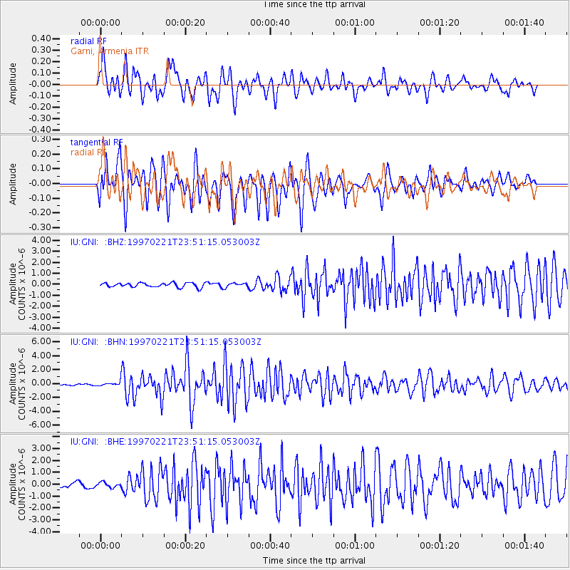
GNI Garni, Armenia - Earthquake Result Viewer
*The percent match for this event was below the threshold and hence no stack was calculated.
| Earthquake location: |
East Of Kuril Islands |
| Earthquake latitude/longitude: |
43.8/149.2 |
| Earthquake time(UTC): |
1997/02/21 (052) 23:40:24 GMT |
| Earthquake Depth: |
33 km |
| Earthquake Magnitude: |
6.1 MB, 5.6 MS, 6.1 UNKNOWN, 6.1 MW |
| Earthquake Catalog/Contributor: |
WHDF/NEIC |
|
| Network: |
IU Global Seismograph Network (GSN - IRIS/USGS) |
| Station: |
GNI Garni, Armenia |
| Lat/Lon: |
40.15 N/44.74 E |
| Elevation: |
1609 m |
|
| Distance: |
72.2 deg |
| Az: |
308.787 deg |
| Baz: |
47.39 deg |
| Ray Param: |
$rayparam |
*The percent match for this event was below the threshold and hence was not used in the summary stack. |
|
| Radial Match: |
79.3926 % |
| Radial Bump: |
400 |
| Transverse Match: |
82.184875 % |
| Transverse Bump: |
400 |
| SOD ConfigId: |
4480 |
| Insert Time: |
2010-03-03 13:55:49.494 +0000 |
| GWidth: |
2.5 |
| Max Bumps: |
400 |
| Tol: |
0.001 |
|
Signal To Noise
| Channel | StoN | STA | LTA |
| IU:GNI: :BHN:19970221T23:51:15.053003Z | 2.2666135 | 3.7672825E-7 | 1.6620753E-7 |
| IU:GNI: :BHE:19970221T23:51:15.053003Z | 1.2498097 | 2.1273301E-7 | 1.7021232E-7 |
| IU:GNI: :BHZ:19970221T23:51:15.053003Z | 0.97002536 | 1.8945218E-7 | 1.9530643E-7 |
| Arrivals |
| Ps | |
| PpPs | |
| PsPs/PpSs | |


