You are here: Home > Network List > XD14 - Illuminating the architecture of the greater Mount St. Helens magmatic systems f Stations List
> Station MH07 "Mount St Helens, WA" > Earthquake Result Viewer
MH07 "Mount St Helens, WA" - Earthquake Result Viewer
| Earthquake location: |
Southeast Of Honshu, Japan |
| Earthquake latitude/longitude: |
30.8/143.0 |
| Earthquake time(UTC): |
2015/05/30 (150) 18:49:07 GMT |
| Earthquake Depth: |
13 km |
| Earthquake Magnitude: |
6.4 MO |
| Earthquake Catalog/Contributor: |
NEIC PDE/NEIC ALERT |
|
| Network: |
XD Illuminating the architecture of the greater Mount St. Helens magmatic systems f |
| Station: |
MH07 "Mount St Helens, WA" |
| Lat/Lon: |
46.28 N/122.08 W |
| Elevation: |
1122 m |
|
| Distance: |
71.6 deg |
| Az: |
46.742 deg |
| Baz: |
295.332 deg |
| Ray Param: |
0.0542171 |
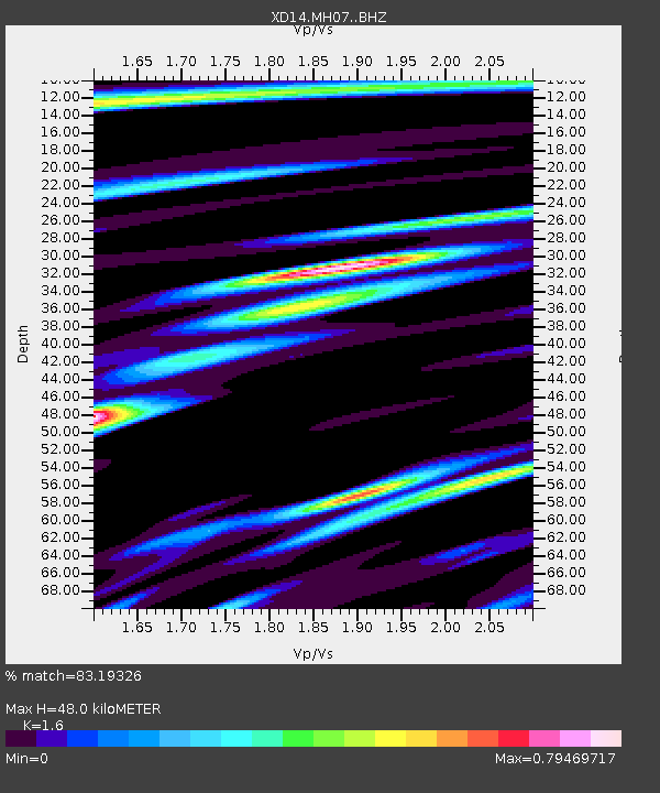
| Estimated Moho Depth: |
48.0 km |
| Estimated Crust Vp/Vs: |
1.60 |
| Assumed Crust Vp: |
6.566 km/s |
| Estimated Crust Vs: |
4.104 km/s |
| Estimated Crust Poisson's Ratio: |
0.18 |
|
| Radial Match: |
83.19326 % |
| Radial Bump: |
400 |
| Transverse Match: |
63.004265 % |
| Transverse Bump: |
400 |
| SOD ConfigId: |
7422571 |
| Insert Time: |
2019-04-19 03:52:11.167 +0000 |
| GWidth: |
2.5 |
| Max Bumps: |
400 |
| Tol: |
0.001 |
|

Signal To Noise
| Channel | StoN | STA | LTA |
| XD:MH07: :BHZ:20150530T18:59:57.649976Z | 7.6521416 | 7.017671E-7 | 9.1708586E-8 |
| XD:MH07: :BHN:20150530T18:59:57.649976Z | 3.910517 | 5.015434E-7 | 1.2825501E-7 |
| XD:MH07: :BHE:20150530T18:59:57.649976Z | 2.0221887 | 1.6688332E-7 | 8.252609E-8 |
| Arrivals |
| Ps | 4.6 SECOND |
| PpPs | 18 SECOND |
| PsPs/PpSs | 23 SECOND |


